Geolocate

Doccombe topographic map

Click on the map to display elevation.

About this map

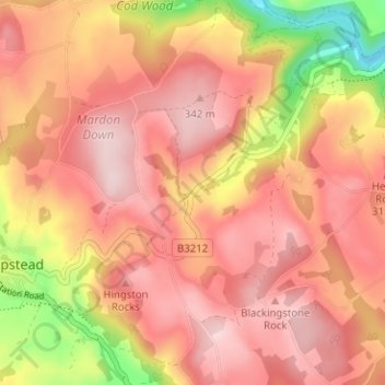
Name: Doccombe topographic map, elevation, terrain.

Location: Doccombe, Moretonhampstead, Teignbridge, Devon, England, TQ13 8SS, United Kingdom (50.64862 -3.75192 50.68862 -3.71192)

Average elevation: 863 ft

Minimum elevation: 259 ft

Maximum elevation: 1,168 ft

Other topographic maps

Click on a map to view its topography, its elevation and its terrain.

Gear up for your next adventure:

🔋Rechargeable Batteries - Power up your outdoor devices
🌐World Map Poster - Decorative world maps with topographic info
🔥Plasma Lighters - Windproof lighters that work in any weather condition
📖Nature Tracking Books - Learn to track wildlife and terrain
🧭Compass with Lanyard - Easy‑carry compass for navigation

As an Amazon Associate, this site earns from qualifying purchases at no extra cost to you.