Geolocate

Shaki topographic map

Click on the map to display elevation.

About this map

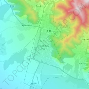
Name: Shaki topographic map, elevation, terrain.

Location: Shaki, Sheki-Zaqatala, Azerbaijan (41.12237 47.13421 41.24243 47.21620)

Average elevation: 2,172 ft

Minimum elevation: 863 ft

Maximum elevation: 6,854 ft

Other topographic maps

Click on a map to view its topography, its elevation and its terrain.

Qasbinə

Azerbaijan > Sheki-Zaqatala

Average elevation: 1,043 ft

Durca

Azerbaijan > Sheki-Zaqatala

Average elevation: 5,413 ft

Seven Churches Monastery

Azerbaijan > Sheki-Zaqatala > Ləkit

Average elevation: 2,300 ft

Gear up for your next adventure:

🎒Waterproof Dry Bags - Keep your electronics and maps dry inside your pack
🥩Freeze-Dried Meals - Nutritious and lightweight food for remote expeditions
🎒Gear Packing Cubes - Organize your backpack efficiently
🔌USB Car Charger - Car charger for on‑the‑go power needs
🍳Camping Cook Set - Complete cookware for outdoor meals

As an Amazon Associate, this site earns from qualifying purchases at no extra cost to you.