
Bellentre topographic map
Click on the map to display elevation.
Bellentre
Sous l'impulsion de son maire Auguste Mudry, la station village de Montchavin, à 1 250 m d'altitude, voit le jour en 1972.
About this map
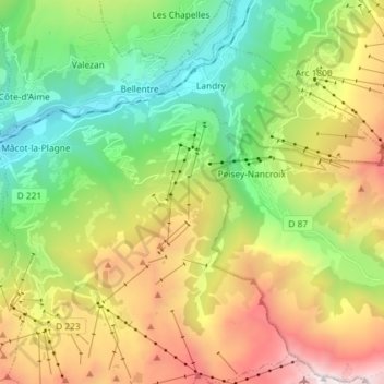
Name: Bellentre topographic map, elevation, terrain.
Average elevation: 5,591 ft
Minimum elevation: 2,169 ft
Maximum elevation: 11,168 ft
Other topographic maps
Click on a map to view its topography, its elevation and its terrain.
Plagne Villages
France > Auvergne-Rhône-Alpes > Savoie > La Plagne-Tarentaise
Average elevation: 6,903 ft
Plagne Centre
France > Auvergne-Rhône-Alpes > Savoie > La Plagne-Tarentaise
Average elevation: 6,818 ft
Les Chacruets
France > Auvergne-Rhône-Alpes > Savoie > La Plagne-Tarentaise
Average elevation: 3,638 ft
Plan Gagnant
France > Auvergne-Rhône-Alpes > Savoie > La Plagne-Tarentaise
Average elevation: 5,213 ft
Mâcot-la-Plagne
France > Auvergne-Rhône-Alpes > Savoie > La Plagne-Tarentaise
Average elevation: 3,330 ft
Le Ceriseray
France > Auvergne-Rhône-Alpes > Savoie > La Plagne-Tarentaise
Average elevation: 4,596 ft
Belle Plagne
France > Auvergne-Rhône-Alpes > Savoie > La Plagne-Tarentaise
Average elevation: 7,231 ft
Plan d'eau Base de loisirs
France > Auvergne-Rhône-Alpes > Savoie > La Plagne-Tarentaise > Le Villard de Sangot
Average elevation: 3,074 ft
Plagne Soleil
France > Auvergne-Rhône-Alpes > Savoie > La Plagne-Tarentaise
Average elevation: 6,870 ft
Le Villard de Sangot
France > Auvergne-Rhône-Alpes > Savoie > La Plagne-Tarentaise
Average elevation: 3,556 ft
Les Chacruets
France > Auvergne-Rhône-Alpes > Savoie > La Plagne-Tarentaise
Average elevation: 3,638 ft
Plagne Centre
France > Auvergne-Rhône-Alpes > Savoie > La Plagne-Tarentaise
Average elevation: 6,818 ft