
Make a donation
Gear up for your next adventure:
As an Amazon Associate, this site earns from qualifying purchases at no extra cost to you.
Kirkby Mallory topographic map
Click on the map to display elevation.
Make a donation
Gear up for your next adventure:
As an Amazon Associate, this site earns from qualifying purchases at no extra cost to you.
About this map
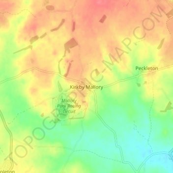
Name: Kirkby Mallory topographic map, elevation, terrain.
Average elevation: 377 ft
Minimum elevation: 272 ft
Maximum elevation: 469 ft
Make a donation
Gear up for your next adventure:
As an Amazon Associate, this site earns from qualifying purchases at no extra cost to you.
Other topographic maps
Click on a map to view its topography, its elevation and its terrain.
Market Bosworth Country Park
United Kingdom > England > Leicestershire > Hinckley and Bosworth > Market Bosworth
Average elevation: 390 ft
Markfield
United Kingdom > England > Leicestershire > Hinckley and Bosworth > Markfield
Average elevation: 571 ft
Groby
United Kingdom > England > Leicestershire > Hinckley and Bosworth > Groby
Average elevation: 351 ft
Make a donation
Gear up for your next adventure:
As an Amazon Associate, this site earns from qualifying purchases at no extra cost to you.
Newbold Verdon
United Kingdom > England > Leicestershire > Hinckley and Bosworth
Average elevation: 423 ft
Burbage
United Kingdom > England > Leicestershire > Hinckley and Bosworth > Stretton Baskerville
Average elevation: 361 ft
Stoke Golding
United Kingdom > England > Leicestershire > Hinckley and Bosworth
Average elevation: 335 ft
Thornton Reservoir
United Kingdom > England > Leicestershire > Hinckley and Bosworth > Thornton
Average elevation: 456 ft
Make a donation
Gear up for your next adventure:
As an Amazon Associate, this site earns from qualifying purchases at no extra cost to you.
Earl Shilton
United Kingdom > England > Leicestershire > Hinckley and Bosworth
Average elevation: 331 ft
Higham on the Hill
United Kingdom > England > Leicestershire > Hinckley and Bosworth
Average elevation: 308 ft
Make a donation
Gear up for your next adventure:
As an Amazon Associate, this site earns from qualifying purchases at no extra cost to you.
Barlestone
United Kingdom > England > Leicestershire > Hinckley and Bosworth
Average elevation: 449 ft
Desford
United Kingdom > England > Leicestershire > Hinckley and Bosworth > Botcheston
Average elevation: 377 ft
Market Bosworth
United Kingdom > England > Leicestershire > Hinckley and Bosworth
Average elevation: 338 ft
Make a donation
Gear up for your next adventure:
As an Amazon Associate, this site earns from qualifying purchases at no extra cost to you.
Shackerstone
United Kingdom > England > Leicestershire > Hinckley and Bosworth
Average elevation: 341 ft
Billa Barra Hill
United Kingdom > England > Leicestershire > Hinckley and Bosworth > Stanton under Bardon
Average elevation: 627 ft
Bagworth Heath Woods
United Kingdom > England > Leicestershire > Hinckley and Bosworth > Thornton
Average elevation: 453 ft
Make a donation
Gear up for your next adventure:
As an Amazon Associate, this site earns from qualifying purchases at no extra cost to you.
Burroughs Wood
United Kingdom > England > Leicestershire > Hinckley and Bosworth > Botcheston
Average elevation: 374 ft
Stanton-under-Bardon
United Kingdom > England > Leicestershire > Hinckley and Bosworth
Average elevation: 561 ft
Earl Shilton
United Kingdom > England > Leicestershire > Hinckley and Bosworth
Average elevation: 331 ft
Barlestone
United Kingdom > England > Leicestershire > Hinckley and Bosworth
Average elevation: 449 ft
Make a donation
Gear up for your next adventure:
As an Amazon Associate, this site earns from qualifying purchases at no extra cost to you.