Geolocate

Mico topographic map

Click on the map to display elevation.

About this map

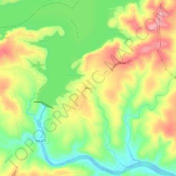
Name: Mico topographic map, elevation, terrain.

Location: Mico, Medina County, Texas, 78056, United States (29.52412 -98.94309 29.56412 -98.90309)

Average elevation: 1,096 ft

Minimum elevation: 912 ft

Maximum elevation: 1,296 ft

Medina County trails, hiking, mountain biking, running and outdoor activities

Other topographic maps

Click on a map to view its topography, its elevation and its terrain.

Devine

United States > Texas > Medina County

Average elevation: 669 ft

Castroville

United States > Texas > Medina County

Average elevation: 817 ft

Castroville

United States > Texas > Medina County

Average elevation: 817 ft

La Coste

United States > Texas > Medina County

Average elevation: 728 ft

Gear up for your next adventure:

🔋Rechargeable Batteries - Power up your outdoor devices
🥩Freeze-Dried Meals - Nutritious and lightweight food for remote expeditions
🕶️Glacier Sunglasses - Side shields to protect eyes from high-altitude snow glare
🍳Camping Cook Set - Complete cookware for outdoor meals
📶Satellite Messenger - Communication device off‑grid

As an Amazon Associate, this site earns from qualifying purchases at no extra cost to you.