Geolocate

Castroville topographic map

Click on the map to display elevation.

About this map

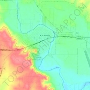
Name: Castroville topographic map, elevation, terrain.

Location: Castroville, Medina County, Texas, United States (29.33486 -98.89896 29.36731 -98.84116)

Average elevation: 817 ft

Minimum elevation: 709 ft

Maximum elevation: 978 ft

Medina County trails, hiking, mountain biking, running and outdoor activities

Other topographic maps

Click on a map to view its topography, its elevation and its terrain.

Mico

United States > Texas > Medina County

Average elevation: 1,096 ft

D'Hanis

United States > Texas > Medina County

D'Hanis is at an elevation of 883 feet (269 m) above sea level.

Average elevation: 896 ft

Castroville

United States > Texas > Medina County

Average elevation: 817 ft

Coal Mine

United States > Texas > Medina County > Lytle

Average elevation: 741 ft

Noonan

United States > Texas > Medina County

Average elevation: 810 ft

Gear up for your next adventure:

📚USA Hiking Guide Books - Top trail guides and map books
🗺️NatGeo Topo Maps - High-quality waterproof printed topographic maps of US Parks
👟Men's Trail Runners - Lightweight footwear for fast-paced exploration and light hiking
🏕️Tent Footprint - Protect your tent base from wear
🌡️Handheld Weather Meters - Measure wind, temp, and pressure for safe mountain travel

As an Amazon Associate, this site earns from qualifying purchases at no extra cost to you.