
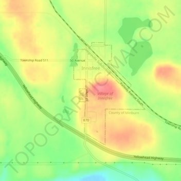
Village of Innisfree topographic map
Interactive map
Click on the map to display elevation.
About this map
Name: Village of Innisfree topographic map, elevation, terrain.
Average elevation: 2,228 ft
Minimum elevation: 2,093 ft
Maximum elevation: 2,346 ft
Other topographic maps
Click on a map to view its topography, its elevation and its terrain.
Meeting Creek
Canada > Alberta > Division No. 10
Meeting Creek, Division No. 10, Alberta, Canada
Average elevation: 2,503 ft
Bashaw
Canada > Alberta > Division No. 10
Bashaw, Division No. 10, Alberta, T0B 0H0, Canada
Average elevation: 2,612 ft
Town of Vegreville
Canada > Alberta > Division No. 10
Town of Vegreville, Division No. 10, Alberta, Canada
Average elevation: 2,093 ft
Village of Myrnam
Canada > Alberta > Division No. 10
Village of Myrnam, Division No. 10, Alberta, Canada
Average elevation: 1,998 ft
Camrose
Canada > Alberta > Division No. 10
Camrose, Division No. 10, Alberta, Canada
Average elevation: 2,448 ft
Vermilion
Canada > Alberta > Division No. 10
Vermilion, Division No. 10, Alberta, T9X 1B7, Canada
Average elevation: 2,021 ft