
Rowe topographic map
Click on the map to display elevation.
About this map
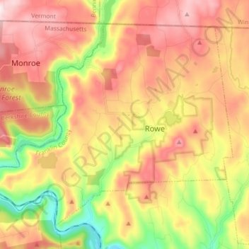
Name: Rowe topographic map, elevation, terrain.
Location: Rowe, Franklin County, Massachusetts, 01367, United States (42.65451 -72.99576 42.73911 -72.85403)
Average elevation: 1,519 ft
Minimum elevation: 594 ft
Maximum elevation: 2,205 ft
Franklin County trails, hiking, mountain biking, running and outdoor activities
Other topographic maps
Click on a map to view its topography, its elevation and its terrain.
Rocky Mountain Park
United States > Massachusetts > Franklin County > Greenfield > Greenfield
Average elevation: 223 ft
Buckland Four Corners
United States > Massachusetts > Franklin County > Buckland
Average elevation: 1,135 ft
Baconville
United States > Massachusetts > Franklin County > Sirius Community
Average elevation: 1,004 ft
Louisiana Mountain
United States > Massachusetts > Franklin County > Northfield
Average elevation: 673 ft