Geolocate

Gleed topographic map

Click on the map to display elevation.

About this map

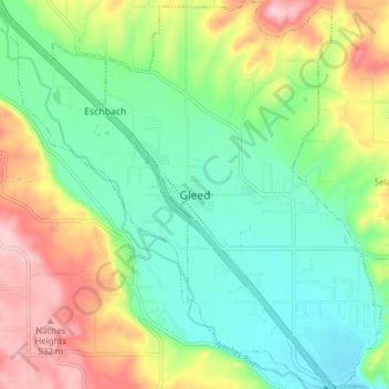
Name: Gleed topographic map, elevation, terrain.

Location: Gleed, Yakima County, Washington, United States (46.63177 -120.63188 46.68460 -120.57637)

Average elevation: 1,391 ft

Minimum elevation: 1,161 ft

Maximum elevation: 1,788 ft

Yakima County trails, hiking, mountain biking, running and outdoor activities

Other topographic maps

Click on a map to view its topography, its elevation and its terrain.

Goose Prairie

United States > Washington > Yakima County

Average elevation: 3,793 ft

Cowiche

United States > Washington > Yakima County

Average elevation: 1,785 ft

Yakima

United States > Washington > Yakima County > Yakima

Average elevation: 1,532 ft

Sunnyside

United States > Washington > Yakima County > Sunnyside > Sunnyside

Average elevation: 784 ft

Pleasant Hill

United States > Washington > Yakima County > Selah

Average elevation: 1,365 ft

Gear up for your next adventure:

📷Action Cameras - Rugged cameras to document your journeys across rugged terrain
🪶Survival Guide Book - Expert advice for emergency preparedness
📱Solar Portable Charger - Solar power bank for charging devices off‑grid
🎒Gear Packing Cubes - Organize your backpack efficiently
🪑Ultralight Camp Chairs - Portable seating for resting after a long day of mapping

As an Amazon Associate, this site earns from qualifying purchases at no extra cost to you.