
Make a donation
Gear up for your next adventure:
As an Amazon Associate, this site earns from qualifying purchases at no extra cost to you.
Compatsch topographic map
Click on the map to display elevation.
Make a donation
Gear up for your next adventure:
As an Amazon Associate, this site earns from qualifying purchases at no extra cost to you.
About this map
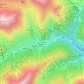
Name: Compatsch topographic map, elevation, terrain.
Average elevation: 6,539 ft
Minimum elevation: 4,843 ft
Maximum elevation: 8,652 ft
Make a donation
Gear up for your next adventure:
As an Amazon Associate, this site earns from qualifying purchases at no extra cost to you.
Other topographic maps
Click on a map to view its topography, its elevation and its terrain.
Samnaun
Schweiz > Graubünden > Region Unterengadin/Münstertal
Die besondere topographische Lage und Beziehung zum benachbarten Tirol sowie die Abwanderung der Reformierten führte im 19. Jahrhundert dazu, dass die Samnauner Bewohner ihre einstige angestammte bündnerromanische Muttersprache Vallader aufgaben. Der Sprachwechsel vom Bündnerromanischen zum Deutschen fing…
Average elevation: 7,772 ft
Scuol
Schweiz > Graubünden > Region Unterengadin/Münstertal
Das Unterengadin wird sowohl gegen Norden von der Silvrettagruppe, als auch gegen Süden durch die Engadiner Dolomiten von mächtigen Bergketten abgeschirmt. Dadurch scheint im Unterengadin oft auch dann die Sonne, während es am Alpennord- oder Südhang in den Staulagen regnet. Anders als das Oberengadin,…
Average elevation: 7,349 ft