Geolocate

Norfork topographic map

Click on the map to display elevation.

About this map

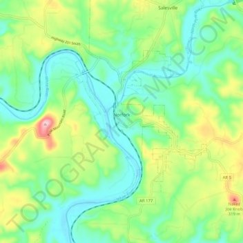
Name: Norfork topographic map, elevation, terrain.

Location: Norfork, Baxter County, Arkansas, 72658, United States (36.18305 -92.34966 36.23137 -92.24903)

Average elevation: 600 ft

Minimum elevation: 335 ft

Maximum elevation: 1,188 ft

Baxter County trails, hiking, mountain biking, running and outdoor activities

Other topographic maps

Click on a map to view its topography, its elevation and its terrain.

Gamaliel

United States > Arkansas > Baxter County

Average elevation: 751 ft

White River

United States > Arkansas > Baxter County

Average elevation: 486 ft

Old Joe

United States > Arkansas > Baxter County

Average elevation: 604 ft

Clarkridge

United States > Arkansas > Baxter County

Average elevation: 787 ft

Buffalo City

United States > Arkansas > Baxter County

Average elevation: 577 ft

Shady Grove

United States > Arkansas > Baxter County

Average elevation: 702 ft

Gear up for your next adventure:

🧭Map Reading Tools - Tools and kits for map navigation
🩳Quick‑Dry Hiking Shorts - Comfortable and quick‑dry shorts for summer hiking
🌡️Portable Weather Meter - Track weather conditions on the trail
🎒Waterproof Dry Bags - Keep your electronics and maps dry inside your pack
Backpacking Tent - Lightweight and durable tent for multi‑day hikes

As an Amazon Associate, this site earns from qualifying purchases at no extra cost to you.