Geolocate

Shady Grove topographic map

Click on the map to display elevation.

About this map

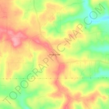
Name: Shady Grove topographic map, elevation, terrain.

Location: Shady Grove, Baxter County, Arkansas, United States (36.23146 -92.39933 36.27146 -92.35933)

Average elevation: 702 ft

Minimum elevation: 486 ft

Maximum elevation: 873 ft

Other topographic maps

Click on a map to view its topography, its elevation and its terrain.

Cotter

United States > Arkansas > Baxter County

Average elevation: 558 ft

White River

United States > Arkansas > Baxter County

Average elevation: 486 ft

Mountain Home

United States > Arkansas > Baxter County

Average elevation: 833 ft

Norfork

United States > Arkansas > Baxter County

Average elevation: 600 ft

Lakeview

United States > Arkansas > Baxter County

Average elevation: 728 ft

Norfork

United States > Arkansas > Baxter County

Average elevation: 600 ft

Lakeview

United States > Arkansas > Baxter County

Average elevation: 728 ft

Mountain Home

United States > Arkansas > Baxter County

Average elevation: 833 ft

Lakeview

United States > Arkansas > Baxter County

Average elevation: 728 ft

Big Flat

United States > Arkansas > Baxter County

Average elevation: 1,161 ft

Gear up for your next adventure:

🎁Geography Themed Gifts - Unique gift ideas for map lovers and geography enthusiasts
🪓Survival Multi‑Tool - Versatile tool for camp and trail tasks
🦺Reflective Outdoor Gear - Safety gear for low‑light conditions
🦟Ultrasonic Repellers - Create a bug-free zone at your camp or rest stop
🌲Outdoor Survival Books - Best books on survival skills

As an Amazon Associate, this site earns from qualifying purchases at no extra cost to you.