Geolocate

Fenwick topographic map

Click on the map to display elevation.

About this map

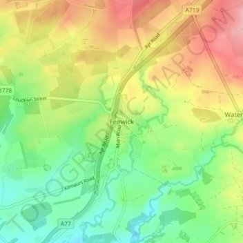
Name: Fenwick topographic map, elevation, terrain.

Location: Fenwick, East Ayrshire, Scotland, KA3 6DX, United Kingdom (55.64168 -4.46393 55.68168 -4.42393)

Average elevation: 466 ft

Minimum elevation: 302 ft

Maximum elevation: 679 ft

Other topographic maps

Click on a map to view its topography, its elevation and its terrain.

Braid Wood

United Kingdom > Scotland > East Ayrshire

Average elevation: 374 ft

Glenbuck Loch

United Kingdom > Scotland > East Ayrshire

Average elevation: 1,073 ft

River Doon

United Kingdom > Scotland > East Ayrshire > Dalrymple

Average elevation: 551 ft

River Ayr

United Kingdom > Scotland > East Ayrshire

Average elevation: 689 ft

Loch Doon

United Kingdom > Scotland > East Ayrshire

Average elevation: 955 ft

Gear up for your next adventure:

Backpacking Tents - Weight-optimized shelters for multi-day topographic surveys
🪵Folding Camp Saw - Compact saw for wood and campsite work
❄️Traction Cleats - Prevent slips on icy trails during winter hikes
🪶Camping Sleeping Pad - Comfortable sleeping pad for backpacking
🪄Magnetic Compass - Accurate compass for navigation

As an Amazon Associate, this site earns from qualifying purchases at no extra cost to you.