Geolocate

Jesi topographic map

Click on the map to display elevation.

About this map

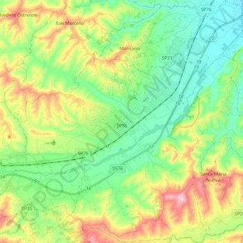
Name: Jesi topographic map, elevation, terrain.

Location: Jesi, Ancona, Marche, Italy (43.45872 13.16904 43.58820 13.34437)

Average elevation: 390 ft

Minimum elevation: 66 ft

Maximum elevation: 1,020 ft

Other topographic maps

Click on a map to view its topography, its elevation and its terrain.

Gabriella

Italy > Marche > Ancona > Senigallia

Average elevation: 138 ft

Gear up for your next adventure:

🔊Portable Camp Speaker - Music and alerts at camp
📱Solar Portable Charger - Solar power bank for charging devices off‑grid
🧥Waterproof Jacket for Hiking - Breathable and rugged rain jacket for outdoor excursions
🏥Hiking First Aid Kits - Comprehensive medical kits for remote trail injuries
🛰️Satellite Messengers - Emergency SOS and two-way messaging for off-grid adventures

As an Amazon Associate, this site earns from qualifying purchases at no extra cost to you.