
宜君县 topographic map
Interactive map
Click on the map to display elevation.
About this map
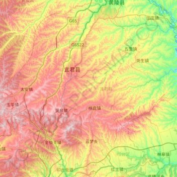
Name: 宜君县 topographic map, elevation, terrain.
Location: 宜君县, 铜川市, 陕西省, 中国 (35.12233 108.91667 35.58204 109.49377)
Average elevation: 3,786 ft
Minimum elevation: 2,333 ft
Maximum elevation: 5,512 ft
宜君县属子午岭余脉,地形地貌复杂,降雨充沛,森林茂密,生物多样性强,是渭北旱原唯一的绿洲。宜君气候特点与西安比偏凉爽,林业用地佔全县总土地面积的一多半。林业物产丰富。
Other topographic maps
Click on a map to view its topography, its elevation and its terrain.