
色乡 topographic map
Interactive map
Click on the map to display elevation.
About this map
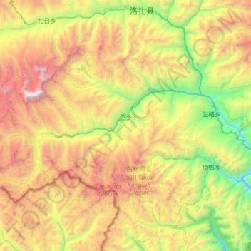
Name: 色乡 topographic map, elevation, terrain.
Location: 色乡, 洛扎县, 山南市, 西藏自治区, 中国 (28.02292 90.44705 28.31386 90.98937)
Average elevation: 15,702 ft
Minimum elevation: 9,954 ft
Maximum elevation: 24,560 ft
Other topographic maps
Click on a map to view its topography, its elevation and its terrain.