
Make a donation
Gear up for your next adventure:
As an Amazon Associate, this site earns from qualifying purchases at no extra cost to you.
Friedrichsthal topographic map
Click on the map to display elevation.
Make a donation
Gear up for your next adventure:
As an Amazon Associate, this site earns from qualifying purchases at no extra cost to you.
Friedrichsthal
Die Stadt Friedrichsthal liegt in der Mitte des Saarkohlenwaldes an einem Ausläufer des Sulzbachtals. Der Stadtteil Friedrichsthal liegt im Tal von Moorbach und Stockbach in einer durchschnittlichen Höhe von 240 – 280 Metern. Der Stadtteil Bildstock erstreckt sich auf einem Höhenzug von etwa 360 Metern zwischen Hoferkopf, Kallenberg (388 m) und Quierschieder Kopf (361 m). Der Stadtteil Maybach liegt unterhalb des Quierschieder Kopfes auf einer Höhe von 320 bis 340 Metern.
Make a donation
Gear up for your next adventure:
As an Amazon Associate, this site earns from qualifying purchases at no extra cost to you.
About this map
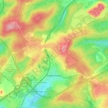
Name: Friedrichsthal topographic map, elevation, terrain.
Average elevation: 1,076 ft
Minimum elevation: 820 ft
Maximum elevation: 1,309 ft
Make a donation
Gear up for your next adventure:
As an Amazon Associate, this site earns from qualifying purchases at no extra cost to you.
Other topographic maps
Click on a map to view its topography, its elevation and its terrain.
Tiefenbachklamm
Deutschland > Saarland > Regionalverband Saarbrücken > Kleinblittersdorf
Average elevation: 886 ft
St. Nikolaus Weiher
Deutschland > Saarland > Regionalverband Saarbrücken > Großrosseln
Average elevation: 833 ft
Make a donation
Gear up for your next adventure:
As an Amazon Associate, this site earns from qualifying purchases at no extra cost to you.
Nagelsberg
Deutschland > Saarland > Regionalverband Saarbrücken > Heusweiler
Average elevation: 827 ft
Staffelberg
Deutschland > Saarland > Regionalverband Saarbrücken > Saarbrücken
Average elevation: 1,086 ft
Großer Homburg
Deutschland > Saarland > Regionalverband Saarbrücken > Saarbrücken
Average elevation: 850 ft
Make a donation
Gear up for your next adventure:
As an Amazon Associate, this site earns from qualifying purchases at no extra cost to you.
Neu-Aschbach
Deutschland > Saarland > Regionalverband Saarbrücken > Saarbrücken
Average elevation: 764 ft
Pfaffenkopf
Deutschland > Saarland > Regionalverband Saarbrücken > Saarbrücken
Average elevation: 965 ft
Make a donation
Gear up for your next adventure:
As an Amazon Associate, this site earns from qualifying purchases at no extra cost to you.
Göttelborn
Deutschland > Saarland > Regionalverband Saarbrücken > Göttelborn
Average elevation: 1,155 ft