French Guiana topographic map
Click on the map to display elevation.
French Guiana
French Guiana has an equatorial climate predominant. Located within six degrees of the Equator and rising only to modest elevations, French Guiana experiences consistently high temperatures and high humidity in all seasons. During most of the year, rainfall across the country is heavy due to the presence of the Intertropical Convergence Zone and its powerful thunderstorm cells. In most parts of French Guiana, rainfall is always heavy especially from December to July – typically over 330 millimetres or 13 inches can be expected each month during this period throughout the department. Between August and November, the eastern half experiences a warm dry season with rainfall below 100 millimetres or 3.94 inches and average high temperatures above 30 °C (86 °F) occurring in September and October, causing eastern French Guiana to be classified as a tropical monsoon climate (Köppen Am); Saint-Laurent-du-Maroni in the west has a tropical rainforest climate (Af).
About this map
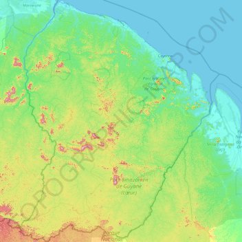
Name: French Guiana topographic map, elevation, terrain.
Location: French Guiana, France (2.11094 -54.60269 5.77695 -51.63461)
Average elevation: 338 ft
Minimum elevation: -7 ft
Maximum elevation: 2,595 ft
Other topographic maps
Click on a map to view its topography, its elevation and its terrain.
Paris
Paris in its early history had only the rivers Seine and Bièvre for water. From 1809, the Canal de l'Ourcq provided Paris with water from less-polluted rivers to the north-east of the capital. From 1857, the civil engineer Eugène Belgrand, under Napoleon III, oversaw the construction of a series of new…
Average elevation: 246 ft

Aix-en-Provence
France > Provence-Alpes-Côte d'Azur > Bouches-du-Rhône > Aix-en-Provence
Average elevation: 915 ft



Aco de Paret
France > Provence-Alpes-Côte d'Azur > Alpes-de-Haute-Provence > Turriers
Average elevation: 3,642 ft

Domaine de Coddes
France > Bourgogne – Franche-Comté > Nièvre > Cercy-la-Tour
Average elevation: 719 ft

Labeyrie
France > Nouvelle-Aquitaine > Lot-et-Garonne > Couthures-sur-Garonne
Average elevation: 69 ft



Carton
France > Auvergne-Rhône-Alpes > Puy-de-Dôme > Saint-Priest-des-Champs
Average elevation: 2,028 ft


Les Bonnefoys
France > Provence-Alpes-Côte d'Azur > Alpes-de-Haute-Provence > Les Omergues
Average elevation: 3,304 ft


Mont Blanc / Monte Bianco
France > Auvergne-Rhône-Alpes > Upper Savoy > Saint-Gervais-les-Bains
The climate is cold and temperate (Köppen climate classification Cfb), and is greatly influenced by altitude. Being the highest part of the Alps, Mont Blanc and surrounding mountains can create their own weather patterns. Temperatures drop as the mountains gain in height, and the summit of Mont Blanc is a…
Average elevation: 13,425 ft




Sur la Duy
France > Bourgogne – Franche-Comté > Côte-d'Or > Source-Seine > Saint-Germain
Average elevation: 1,611 ft
Lotissement du Petit Bourbon
France > Pays de la Loire > Vendée > Essarts-en-Bocage > Les Essarts
Average elevation: 285 ft


Cirque de Gavarnie
France > Occitania > Hautes Pyrenees > Gavarnie-Gèdre > Gavarnie
Average elevation: 7,756 ft


Saint-Brévin l'Océan
France > Pays de la Loire > Loire-Atlantique > Saint-Brevin-les-Pins
Average elevation: 13 ft




Les Escaldes
France > Occitania > Pyrénées-Orientales > Angoustrine-Villeneuve-des-Escaldes
Average elevation: 4,892 ft

Mont Granier
France > Auvergne-Rhône-Alpes > Isère > Chapareillan
454 caves have been identified over an area of 2.8 km2, and form two networks under this small area. To the north, the trou des Auges, ressaut de 108 m, trou des Filous, grotte Arva, and Cuvée des Ours connect with the Granier system, located in the center of the plateau, to form a 55.725 km network over a…
Average elevation: 4,452 ft






Fief des Chênes
France > Nouvelle-Aquitaine > Charente-Maritime > La Rochelle
Average elevation: 13 ft



Grand Ballon
France > Grand Est > Haut-Rhin > Goldbach-Altenbach
According to the Köppen climate classification, the top of the Grand Ballon features a subalpine climate (Köppen: Dfc) due to its high altitude comparable to the Alps or the Pyrenees. Along with the Hohneck the summit of the Grand Ballon is the coldest and windiest point in Alsace. A record low of −30.2…
Average elevation: 3,737 ft
Talau
France > Occitania > Pyrénées-Orientales > Ayguatébia-Talau > Ayguatébia
Average elevation: 4,557 ft


Fief des Chênes
France > Nouvelle-Aquitaine > Charente-Maritime > La Rochelle
Average elevation: 13 ft