Geolocate

Consolacion topographic map

Click on the map to display elevation.

About this map

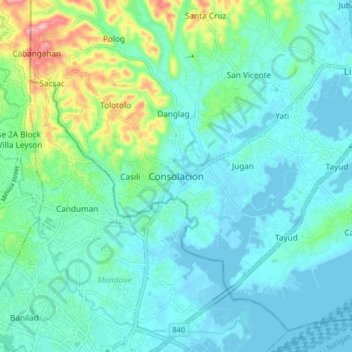
Name: Consolacion topographic map, elevation, terrain.

Location: Consolacion, Cebu, Central Visayas, 6001, Philippines (10.33578 123.91699 10.41578 123.99699)

Average elevation: 98 ft

Minimum elevation: -13 ft

Maximum elevation: 509 ft

Other topographic maps

Click on a map to view its topography, its elevation and its terrain.

Mananga River

Philippines > Cebu > Talisay

Average elevation: 56 ft

Cordova

Philippines > Cebu

The surface of the town consists entirely of karstic limestone rock geologically associated with the Plio-Pleistocene Carcar Formation, dated to 2½–3 million years ago. The topography of Cordova is flat land, the highest point being only 10 metres (33 ft) above sea level.

Average elevation: 0 ft

Oslob

Philippines > Cebu

Generally, the area's topography is hilly and rolling, dominated by open grasslands and second-growth forests. There are fairly level and rolling plateaus and valleys spread throughout the interior. These are some of the most suitable areas for upland agriculture. The highest mountain peak is 800 metres (2,600…

Average elevation: 325 ft

Cebu

Philippines > Cebu > Cebu City

Average elevation: 338 ft

San Francisco

Philippines > Cebu

Average elevation: 26 ft

Logon

Philippines > Cebu

Average elevation: 3 ft

Dumanjug

Philippines > Cebu

Average elevation: 164 ft

Boljoon

Philippines > Cebu

Average elevation: 696 ft

Carnaza

Philippines > Cebu

The island's topography includes coastal plains, mangrove swamps, lagoons and semi-rounded hills. Its coastal plain constitutes about 9.7% while semi-rounded hills constitute the biggest portion of the island covering about 14.4% of the total area. The mangrove forest has an area of about 10.1 hectares or 5.8%…

Average elevation: 0 ft

Poro

Philippines > Cebu

Average elevation: 39 ft

Santander

Philippines > Cebu

Average elevation: 269 ft

Malabuyoc

Philippines > Cebu

Average elevation: 745 ft

Ginatilan

Philippines > Cebu

Average elevation: 669 ft

Jubay River

Philippines > Cebu > Lilo-an

Average elevation: 43 ft

Bantayan Island

Philippines > Cebu > Kangwayan

Average elevation: 16 ft

Malapascua

Philippines > Cebu > Logon

Average elevation: 3 ft

Olango Island

Philippines > Cebu > Lapu-Lapu

Average elevation: 7 ft

Pilar

Philippines > Cebu > Pilar

Average elevation: 30 ft

Nalusuan Island

Philippines > Cebu > Cordova > Gilutongan

Average elevation: 0 ft

Badian Island

Philippines > Cebu > Zaragosa

Average elevation: 23 ft

Maravilla Public Beach

Philippines > Cebu > Maravilla

Average elevation: 79 ft

Catmon Rizal Park

Philippines > Cebu > Catmon

Average elevation: 43 ft

Sumilon Island

Philippines > Cebu > Oslob

Average elevation: 0 ft

Mactan

Philippines > Cebu > Lapu-Lapu

Average elevation: 10 ft

Bojo River

Philippines > Cebu > Bojo

Average elevation: 108 ft

Logon

Philippines > Cebu

Average elevation: 3 ft

Ginatilan

Philippines > Cebu

Average elevation: 669 ft

Santander

Philippines > Cebu

Average elevation: 269 ft

Bantayan Island

Philippines > Cebu > Kangwayan

Average elevation: 16 ft

Dumanjug

Philippines > Cebu

Average elevation: 164 ft

Boljoon

Philippines > Cebu

Average elevation: 696 ft

Ponson Island

Philippines > Cebu > Pilar

Average elevation: 69 ft

Talavera River

Philippines > Cebu > Capitan Claudio

Average elevation: 420 ft

Luyang River

Philippines > Cebu > Carmen

Average elevation: 190 ft

Toledo City Plaza

Philippines > Cebu > Toledo

Average elevation: 30 ft

Oslob

Philippines > Cebu

Generally, the area's topography is hilly and rolling, dominated by open grasslands and second-growth forests. There are fairly level and rolling plateaus and valleys spread throughout the interior. These are some of the most suitable areas for upland agriculture. The highest mountain peak is 800 metres (2,600…

Average elevation: 325 ft

Malapascua

Philippines > Cebu > Logon

Average elevation: 3 ft

Mactan

Philippines > Cebu > Lapu-Lapu

Average elevation: 10 ft

Mactan

Philippines > Cebu > Lapu-Lapu

Average elevation: 10 ft

Mactan

Philippines > Cebu > Lapu-Lapu

Average elevation: 10 ft

Mactan

Philippines > Cebu > Lapu-Lapu

Average elevation: 10 ft

San Francisco

Philippines > Cebu

Average elevation: 26 ft

Gear up for your next adventure:

🛶Inflatable Kayak - Portable kayak for rivers, lakes, and expeditions
🔌Solar Panel Charger - Charge gear sustainably outdoors
🧭GPS Watch Accessories - Bands and chargers for GPS watches
⛑️Personal Locator Beacon - Safety beacon for emergencies
🥘Titanium Cookware - Durable, featherlight pots and pans for backpacking

As an Amazon Associate, this site earns from qualifying purchases at no extra cost to you.