
Southampton topographic map
Click on the map to display elevation.
About this map
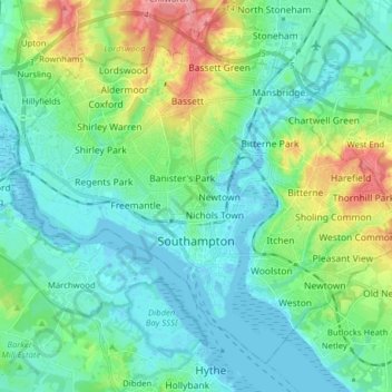
Name: Southampton topographic map, elevation, terrain.
Location: Southampton, England, United Kingdom (50.87151 -1.47901 50.95613 -1.32199)
Average elevation: 72 ft
Minimum elevation: -13 ft
Maximum elevation: 302 ft
Other topographic maps
Click on a map to view its topography, its elevation and its terrain.
City of London
United Kingdom > England > City of London > City of London
The elevation of the City ranges from sea level at the Thames to 21.6 metres (71 ft) at the junction of High Holborn and Chancery Lane. Two small but notable hills are within the historic core, Ludgate Hill to the west and Cornhill to the east. Between them ran the Walbrook, one of the many "lost" rivers or…
Average elevation: 138 ft
Peterborough
United Kingdom > England > Cambridgeshire
The local topography is flat, and in some places, the land lies below sea level, for example in parts of the Fens to the east and to the south of Peterborough. Human settlement in the area began before the Bronze Age, as can be seen at the Flag Fen archaeological site to the east of the current city centre,…
Average elevation: 56 ft
Darwen
United Kingdom > England > Darwen
Much of the town was built between about 1850 and 1900; placenames, date stones in terraces, and the vernacular architecture of cellars, local stone, locally-made brick, pipework and tiles and leaded glass, the last now mostly gone, reflect this. It was one of the first places in the world to have steam trams.…
Average elevation: 791 ft
Cambridge
United Kingdom > England > Cambridge
The city, like most of the UK, has a maritime climate highly influenced by the Gulf Stream. Located in the driest region of Britain, Cambridge's rainfall averages around 570 mm (22.44 in) per year, around half the national average, with some years occasionally falling into the semi-arid (under 500 mm (19.69…
Average elevation: 59 ft
Retford
United Kingdom > England > Nottinghamshire > Bassetlaw
In 1831, the Gas Works was built by James Malam and gaslights were lit in the town for the first time on 22 December 1831. The Square was lit by a cast iron light bearing five gas lamps at that time. The Gas Works became a target on 2 September 1916 when a German Zeppelin dropped 14 bombs on Retford. The…
Average elevation: 102 ft
Maidenhead
United Kingdom > England > Royal Borough of Windsor and Maidenhead
Average elevation: 135 ft
Basingstoke
United Kingdom > England > Hampshire > Basingstoke and Deane
Situated in a valley through the Hampshire Downs at an average elevation of 88 metres (289 ft) Basingstoke is a major interchange between Reading, Newbury, Andover, Winchester, and Alton, and lies on the natural trade route between the southwest of England and London. The area had been something of an…
Average elevation: 358 ft
Pennines
United Kingdom > England > Westmorland and Furness
The Pennine climate is generally temperate like that of the rest of England, but the hills have more precipitation, stronger winds and colder weather than the surrounding areas. Higher elevations have a tundra climate. More snow falls on the Pennines than on surrounding lowland areas due to the elevation and…
Average elevation: 2,497 ft
Hull
United Kingdom > England > Kingston upon Hull
Kingston upon Hull is on the northern bank of the Humber Estuary. The city centre is west of the River Hull and close to the Humber. The city is built upon alluvial and glacial deposits which overlie chalk rocks but the underlying chalk has no influence on the topography. The land within the city is generally…
Average elevation: 69 ft
Caterham
United Kingdom > England > Surrey > Tandridge
In 1840 Caterham contained a total of 477 residents (figures taken from that census, compiled in an 1848 topographical encyclopedia) and in 1848 468 acres (189 ha) of its 2,386 acres (966 ha) were common land. Similar to today, 175 acres (71 ha) mostly steeper acres were woodland.
Average elevation: 515 ft
Salisbury
United Kingdom > England > Salisbury
Bishop of Salisbury Hubert Walter was instrumental in the negotiations with Saladin during the Third Crusade, but he spent little time in his diocese prior to his elevation to archbishop of Canterbury. The brothers Herbert and Richard Poore succeeded him and began planning the relocation of the cathedral into…
Average elevation: 315 ft
Lavender Hall Park
United Kingdom > England > West Midlands Combined Authority > Solihull > Balsall Common
Average elevation: 384 ft
Eltham
United Kingdom > England > Greater London
Eltham has a varied topography. Map 6 shows contours, spot heights and water courses. The centre of Eltham is on a plateau at about the 60m level with the High Street running along its centre. There is a scarp slope to the west of the plateau from the top of which are unrestricted views across South London.…
Average elevation: 157 ft
Stockton-on-Tees
United Kingdom > England > Stockton-on-Tees > Stockton-on-Tees
Average elevation: 56 ft
Swindon
United Kingdom > England > Swindon
Swindon has an oceanic climate (Cfb in the Köppen climate classification), like the vast majority of the British Isles, with cool winters and warm summers. The nearest official weather station is RAF Lyneham, about 10 miles (16 km) west southwest of Swindon town centre. The weather station's elevation is 145…
Average elevation: 354 ft
Brund Fell (summit)
United Kingdom > England > Cumberland > Borrowdale
The fell has a summit plateau which consist of many heather-covered hummocks, drystone walls and clumps of trees. Well-known Lake District writer Alfred Wainwright credits Grange Fell as a single fell with three main summits, namely Brund Fell, King's How and Ether Knott. The lesser known Ether Knott is now…
Average elevation: 827 ft
Great Chishill
United Kingdom > England > Cambridgeshire > South Cambridgeshire
Average elevation: 367 ft
Newcastle-under-Lyme
United Kingdom > England > Staffordshire > Newcastle-under-Lyme
Average elevation: 482 ft
Bradford
Bradford is located at 53°45′00″N 01°50′00″W / 53.75000°N 1.83333°W / 53.75000; -1.83333 (53.7500, -1.8333)1. Topographically, it is located in the eastern moorland region of the South Pennines.
Average elevation: 548 ft
St Albans
United Kingdom > England > Hertfordshire > St Albans
St Albans was an ancient borough created following the dissolution of the monastery in 1539. It consisted of the ancient parish of St Albans (also known as the Abbey parish) and parts of St Michael and St Peter. The municipal corporation was reformed by the Municipal Corporations Act 1835 and the boundary was…
Average elevation: 328 ft
Plymouth
United Kingdom > England > Devon > Plymouth
The River Plym, which flows off Dartmoor to the north-east, forms a smaller estuary to the east of the city called Cattewater. Plymouth Sound is protected from the sea by the Plymouth Breakwater, in use since 1814. In the Sound is Drake's Island which is seen from Plymouth Hoe, a flat public area on top of…
Average elevation: 266 ft