
Make a donation
Gear up for your next adventure:
As an Amazon Associate, this site earns from qualifying purchases at no extra cost to you.
La Maná topographic map
Click on the map to display elevation.
Make a donation
Gear up for your next adventure:
As an Amazon Associate, this site earns from qualifying purchases at no extra cost to you.
About this map
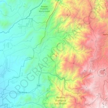
Name: La Maná topographic map, elevation, terrain.
Location: La Maná, Cotopaxi, 050202, Ecuador (-1.00423 -79.32003 -0.56474 -78.98692)
Average elevation: 4,862 ft
Minimum elevation: 384 ft
Maximum elevation: 14,416 ft
Make a donation
Gear up for your next adventure:
As an Amazon Associate, this site earns from qualifying purchases at no extra cost to you.
Other topographic maps
Click on a map to view its topography, its elevation and its terrain.
Make a donation
Gear up for your next adventure:
As an Amazon Associate, this site earns from qualifying purchases at no extra cost to you.
Laguna Quilotoa
Ecuador > Cotopaxi > Sigchos > Chugchillan
Quilotoa is a site of growing popularity. The route to the "summit" (the small town of Quilotoa) is generally traveled by hired truck or bus from the town of Zumbahua 17 kilometres (11 mi) to the South, or more commonly by bus from Latacunga. Visitors have to pay two US dollars each to enter Quilotoa. There…
Average elevation: 11,929 ft
Make a donation
Gear up for your next adventure:
As an Amazon Associate, this site earns from qualifying purchases at no extra cost to you.
Quilotoa
Ecuador > Cotopaxi > Sigchos > Chugchillan
Quilotoa is a site of growing popularity. The route to the "summit" (the small town of Quilotoa) is generally traveled by hired truck or bus from the town of Zumbahua 17 kilometres (11 mi) to the South, or more commonly by bus from Latacunga. Visitors have to pay two US dollars each to enter Quilotoa. There…
Average elevation: 12,208 ft
Make a donation
Gear up for your next adventure:
As an Amazon Associate, this site earns from qualifying purchases at no extra cost to you.