Geolocate

Tavullia topographic map

Click on the map to display elevation.

About this map

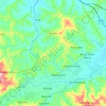
Name: Tavullia topographic map, elevation, terrain.

Location: Tavullia, Pesaro e Urbino, Marche, Italy (43.82595 12.67815 43.93009 12.82478)

Average elevation: 312 ft

Minimum elevation: 52 ft

Maximum elevation: 1,217 ft

Other topographic maps

Click on a map to view its topography, its elevation and its terrain.

Lucrezia

Italy > Marche > Pesaro e Urbino

Average elevation: 223 ft

San Lazzaro

Italy > Marche > Pesaro e Urbino > Fossombrone

Average elevation: 1,001 ft

Gear up for your next adventure:

🪓Survival Multi‑Tool - Versatile tool for camp and trail tasks
🛰️Handheld GPS Units - Professional satellite navigators for precise backcountry mapping
🌎3D Topographic Globes - Raised relief globes for a tactile understanding of geography
🪑Portable Camp Table - Compact table for campsite meals
🪶Camp Gear Gift Set - Perfect gift bundle for outdoor fans

As an Amazon Associate, this site earns from qualifying purchases at no extra cost to you.