Geolocate

Preston topographic map

Click on the map to display elevation.

About this map

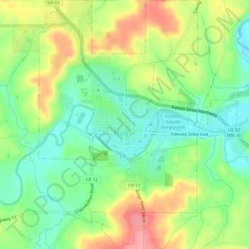
Name: Preston topographic map, elevation, terrain.

Location: Preston, Fillmore County, Minnesota, 55965, United States (43.65449 -92.09948 43.68841 -92.06208)

Average elevation: 1,047 ft

Minimum elevation: 906 ft

Maximum elevation: 1,243 ft

Fillmore County trails, hiking, mountain biking, running and outdoor activities

Other topographic maps

Click on a map to view its topography, its elevation and its terrain.

Chatfield

United States > Minnesota > Fillmore County

Average elevation: 1,073 ft

Highland

United States > Minnesota > Fillmore County

Average elevation: 1,152 ft

Gear up for your next adventure:

🛏️Cold Weather Sleeping Bag - Warm sleeping bag for cold conditions
🎒Waterproof Dry Bags - Keep your electronics and maps dry inside your pack
🔦Compact Flashlight - Reliable flashlight for emergencies
GPS Sports Watch - GPS watch for running, hiking and training
🧦Hiking Socks - Comfortable socks to prevent blisters on long hikes

As an Amazon Associate, this site earns from qualifying purchases at no extra cost to you.