Geolocate

Chatfield topographic map

Click on the map to display elevation.

About this map

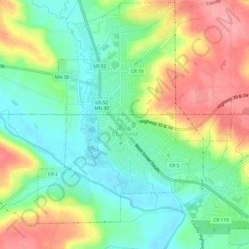
Name: Chatfield topographic map, elevation, terrain.

Location: Chatfield, Fillmore County, Minnesota, 55923, United States (43.82981 -92.20397 43.86184 -92.15875)

Average elevation: 1,073 ft

Minimum elevation: 942 ft

Maximum elevation: 1,263 ft

Fillmore County trails, hiking, mountain biking, running and outdoor activities

Other topographic maps

Click on a map to view its topography, its elevation and its terrain.

Rushford

United States > Minnesota > Fillmore County

Average elevation: 837 ft

Preston

United States > Minnesota > Fillmore County

Average elevation: 1,047 ft

Wykoff

United States > Minnesota > Fillmore County

Average elevation: 1,306 ft

Whalan

United States > Minnesota > Fillmore County

Average elevation: 932 ft

Mabel

United States > Minnesota > Fillmore County

Average elevation: 1,148 ft

Ostrander

United States > Minnesota > Fillmore County

Average elevation: 1,335 ft

Peterson

United States > Minnesota > Fillmore County

Average elevation: 879 ft

Fountain

United States > Minnesota > Fillmore County

Fountain is claimed as the sinkhole capital of the United States of America due to the prevalence of karst topography.

Average elevation: 1,270 ft

Canton

United States > Minnesota > Fillmore County

Average elevation: 1,322 ft

Lanesboro

United States > Minnesota > Fillmore County

Average elevation: 981 ft

Highland

United States > Minnesota > Fillmore County

Average elevation: 1,152 ft

Gear up for your next adventure:

🎒Hydration Pack - Hands‑free water reservoir for long hikes
🔦Powerful Headlamps - Ultra-bright hands-free lighting for night navigation
📖Nature Tracking Books - Learn to track wildlife and terrain
🛏️Cold Weather Sleeping Bag - Warm sleeping bag for cold conditions
🧦Hiking Socks - Comfortable socks to prevent blisters on long hikes

As an Amazon Associate, this site earns from qualifying purchases at no extra cost to you.