
Hachimantai topographic map
Interactive map
Click on the map to display elevation.
About this map
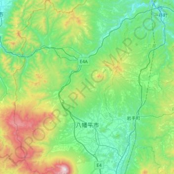
Name: Hachimantai topographic map, elevation, terrain.
Location: Hachimantai, Iwate Prefecture, Tohoku, Japan (39.83993 140.84436 40.24764 141.16908)
Average elevation: 1,801 ft
Minimum elevation: 384 ft
Maximum elevation: 6,634 ft
Other topographic maps
Click on a map to view its topography, its elevation and its terrain.
Lake Towada
Lake Towada, Towada Prince Hotel, Kosaka, Kazuno, Akita Prefecture, Tohoku, 0185501, Japan
Average elevation: 1,608 ft
Mt. Gassan
Mt. Gassan, Tsuruoka, Yamagata Prefecture, Tohoku, Japan
Average elevation: 5,479 ft