
Akita topographic map
Interactive map
Click on the map to display elevation.
About this map
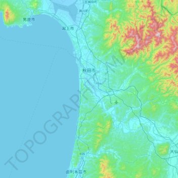
Name: Akita topographic map, elevation, terrain.
Location: Akita, Akita Prefecture, Tohoku, Japan (39.44889 139.75704 39.86503 140.51560)
Average elevation: 351 ft
Minimum elevation: -16 ft
Maximum elevation: 3,776 ft
Other topographic maps
Click on a map to view its topography, its elevation and its terrain.
Lake Towada
Lake Towada, Towada Prince Hotel, Kosaka, Kazuno, Akita Prefecture, Tohoku, 0185501, Japan
Average elevation: 1,608 ft
Mt. Gassan
Mt. Gassan, Tsuruoka, Yamagata Prefecture, Tohoku, Japan
Average elevation: 5,479 ft