
Hachinohe topographic map
Interactive map
Click on the map to display elevation.
About this map
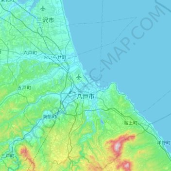
Name: Hachinohe topographic map, elevation, terrain.
Location: Hachinohe, Aomori Prefecture, Japan (40.34736 141.35448 40.72181 141.85796)
Average elevation: 236 ft
Minimum elevation: -7 ft
Maximum elevation: 2,388 ft
Other topographic maps
Click on a map to view its topography, its elevation and its terrain.
Lake Towada
Lake Towada, Towada Prince Hotel, Kosaka, Kazuno, Akita Prefecture, Tohoku, 0185501, Japan
Average elevation: 1,608 ft
Mt. Gassan
Mt. Gassan, Tsuruoka, Yamagata Prefecture, Tohoku, Japan
Average elevation: 5,479 ft