
Thank you for supporting this site ❤️
Make a donation
Make a donation
Gear up for your next adventure:
As an Amazon Associate, this site earns from qualifying purchases at no extra cost to you.
Cambridge topographic map
Click on the map to display elevation.
Thank you for supporting this site ❤️
Make a donation
Make a donation
Gear up for your next adventure:
As an Amazon Associate, this site earns from qualifying purchases at no extra cost to you.
About this map
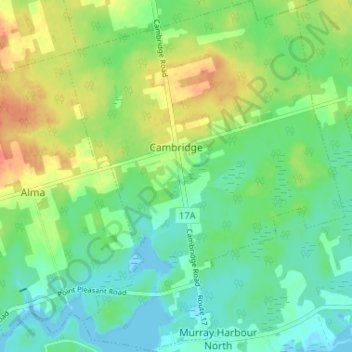
Name: Cambridge topographic map, elevation, terrain.
Location: Cambridge, Kings County, Prince Edward Island, Canada (46.04819 -62.54643 46.09330 -62.49453)
Average elevation: 56 ft
Minimum elevation: -16 ft
Maximum elevation: 144 ft
Thank you for supporting this site ❤️
Make a donation
Make a donation
Gear up for your next adventure:
As an Amazon Associate, this site earns from qualifying purchases at no extra cost to you.
Other topographic maps
Click on a map to view its topography, its elevation and its terrain.
Prince Edward Island National Park
Canada > Prince Edward Island > Kings County > Greenwich
Average elevation: 7 ft