
Make a donation
Gear up for your next adventure:
As an Amazon Associate, this site earns from qualifying purchases at no extra cost to you.
Poquito Bayou topographic map
Click on the map to display elevation.
Make a donation
Gear up for your next adventure:
As an Amazon Associate, this site earns from qualifying purchases at no extra cost to you.
About this map
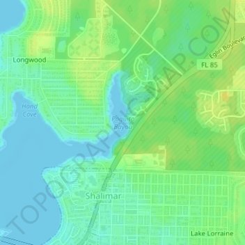
Name: Poquito Bayou topographic map, elevation, terrain.
Average elevation: 30 ft
Minimum elevation: -3 ft
Maximum elevation: 62 ft
Okaloosa County trails, hiking, mountain biking, running and outdoor activities
Make a donation
Gear up for your next adventure:
As an Amazon Associate, this site earns from qualifying purchases at no extra cost to you.
Other topographic maps
Click on a map to view its topography, its elevation and its terrain.
Make a donation
Gear up for your next adventure:
As an Amazon Associate, this site earns from qualifying purchases at no extra cost to you.
Eglin Air Force Base
United States > Florida > Okaloosa County
Eglin is known to have been used for 441 launches from 1959 to 1980, reaching up to 686 kilometers altitude.
Average elevation: 39 ft
Make a donation
Gear up for your next adventure:
As an Amazon Associate, this site earns from qualifying purchases at no extra cost to you.