Geolocate

Spiazzi topographic map

Click on the map to display elevation.

About this map

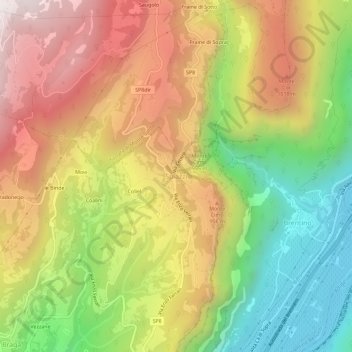
Name: Spiazzi topographic map, elevation, terrain.

Location: Spiazzi, Caprino Veronese, Verona, Veneto, Italy (45.62780 10.83241 45.66780 10.87241)

Average elevation: 2,326 ft

Minimum elevation: 335 ft

Maximum elevation: 4,350 ft

Other topographic maps

Click on a map to view its topography, its elevation and its terrain.

Brenzone sul Garda

Italy > Veneto > Verona

Average elevation: 2,241 ft

Cerea

Italy > Veneto > Verona

Average elevation: 46 ft

Nogara

Italy > Veneto > Verona

Average elevation: 62 ft

Lazise

Italy > Veneto > Verona

Average elevation: 331 ft

Minerbe

Italy > Veneto > Verona

Average elevation: 52 ft

Mozzecane

Italy > Veneto > Verona

Average elevation: 154 ft

Sommacampagna

Italy > Veneto > Verona

Average elevation: 295 ft

Isola del Sogno

Italy > Veneto > Verona > Cassone

Average elevation: 499 ft

Bardolino

Italy > Veneto > Verona > Bardolino

Average elevation: 384 ft

Colognola ai Colli

Italy > Veneto > Verona

Average elevation: 213 ft

Sant'Anna d'Alfaedo

Italy > Veneto > Verona

Average elevation: 2,743 ft

Veronella

Italy > Veneto > Verona

Average elevation: 69 ft

Gear up for your next adventure:

🧣Hiking Neck Gaiter - Multi‑use neck protection for outdoor weather
🪶Fire Starter Kit - Reliable fire starter for survival and camping
🦟Ultrasonic Repellers - Create a bug-free zone at your camp or rest stop
📶Satellite Messenger - Communication device off‑grid
🛡️Bear Spray Outdoor - Protection in bear country hikes

As an Amazon Associate, this site earns from qualifying purchases at no extra cost to you.