
Mount Steller topographic map
Click on the map to display elevation.
Mount Steller
Due to its isolated location, poor weather, and comparatively low absolute elevation by Alaskan standards, Mount Steller was not climbed until recently. The first ascent was in 1992.
About this map
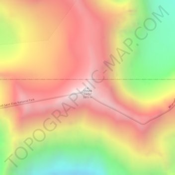
Name: Mount Steller topographic map, elevation, terrain.
Location: Mount Steller, Yakutat, Alaska, United States (60.52049 -143.09217 60.52059 -143.09207)
Average elevation: 8,458 ft
Minimum elevation: 5,764 ft
Maximum elevation: 10,525 ft
Yakutat trails, hiking, mountain biking, running and outdoor activities
Other topographic maps
Click on a map to view its topography, its elevation and its terrain.
Hubbard Glacier
United States > Alaska > Yakutat
The longest source for Hubbard Glacier originates 122 kilometres (76 mi) from its snout and is located at about 61°00′N 140°09′W / 61.000°N 140.150°W / 61.000; -140.150, approximately 8 kilometres (5 mi) west of Mount Walsh with an elevation around 3,400 metres (11,200 ft). A shorter tributary…
Average elevation: 6,207 ft
Malaspina Glacier
United States > Alaska > Yakutat
The Malaspina is up to 600 meters (2,000 ft) thick in places, with the elevation of its bottom being estimated to be as much as 300 m (980 ft) below sea level. There are two lakes on its margins: Oily Lake to the northwest, at the foot of the Samovar Hills between the Agassiz and Seward glaciers, and Malaspina…
Average elevation: 1,289 ft
Hubbard Glacier
United States > Alaska > Yakutat
The longest source for Hubbard Glacier originates 122 kilometres (76 mi) from its snout and is located at about 61°00′N 140°09′W / 61.000°N 140.150°W / 61.000; -140.150, approximately 8 kilometres (5 mi) west of Mount Walsh with an elevation around 3,400 metres (11,200 ft). A shorter tributary…
Average elevation: 6,207 ft
Malaspina Glacier
United States > Alaska > Yakutat
The Malaspina is up to 600 meters (2,000 ft) thick in places, with the elevation of its bottom being estimated to be as much as 300 m (980 ft) below sea level. There are two lakes on its margins: Oily Lake to the northwest, at the foot of the Samovar Hills between the Agassiz and Seward glaciers, and Malaspina…
Average elevation: 1,289 ft