
Humphrey topographic map
Click on the map to display elevation.
About this map
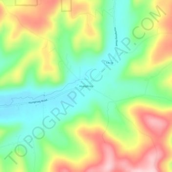
Name: Humphrey topographic map, elevation, terrain.
Average elevation: 1,860 ft
Minimum elevation: 1,555 ft
Maximum elevation: 2,293 ft
Cattaraugus County trails, hiking, mountain biking, running and outdoor activities
Other topographic maps
Click on a map to view its topography, its elevation and its terrain.
Weston Mills
United States > New York > Cattaraugus County > Town of Portville
Average elevation: 1,611 ft
Saint Bonaventure
United States > New York > Cattaraugus County > Town of Allegany
Average elevation: 1,453 ft