
Make a donation
Gear up for your next adventure:
As an Amazon Associate, this site earns from qualifying purchases at no extra cost to you.
Mount Phillips topographic map
Click on the map to display elevation.
Make a donation
Gear up for your next adventure:
As an Amazon Associate, this site earns from qualifying purchases at no extra cost to you.
About this map
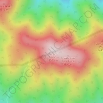
Name: Mount Phillips topographic map, elevation, terrain.
Location: Mount Phillips, Colfax County, New Mexico, United States (36.47662 -105.15955 36.47672 -105.15945)
Average elevation: 10,853 ft
Minimum elevation: 9,849 ft
Maximum elevation: 11,726 ft
Colfax County trails, hiking, mountain biking, running and outdoor activities
Make a donation
Gear up for your next adventure:
As an Amazon Associate, this site earns from qualifying purchases at no extra cost to you.
Other topographic maps
Click on a map to view its topography, its elevation and its terrain.
Angel Fire
United States > New Mexico > Colfax County
Angel Fire is located in southwestern Colfax County at 36°22′44″N 105°17′8″W / 36.37889°N 105.28556°W / 36.37889; -105.28556 (36.378808, -105.285658). The village center is in the valley of Cieneguilla Creek, with housing developments climbing mountain slopes to the east and west. Angel…
Average elevation: 9,140 ft
Raton
United States > New Mexico > Colfax County
Sugarite Canyon State Park is located 12 miles (19 km) northeast of Raton at an elevation of 8,800 feet (2,700 m). Activities there include camping, fishing, and hiking.
Average elevation: 6,693 ft
Make a donation
Gear up for your next adventure:
As an Amazon Associate, this site earns from qualifying purchases at no extra cost to you.
Lake Maloya
United States > New Mexico > Colfax County
Lake Maloya is a reservoir in Sugarite Canyon State Park on the New Mexico-Colorado State border, northeast of Raton, New Mexico. It is the main source of water for the city and its outlying areas. When full, the lake's surface has an elevation of 7,516 feet (2,291 meters).
Average elevation: 7,831 ft
Angel Fire
United States > New Mexico > Colfax County
Angel Fire is located in southwestern Colfax County. The village center is in the valley of Cieneguilla Creek, with housing developments climbing mountain slopes to the east and west. Angel Fire Resort, entirely within the village limits, is on the east side of the valley, with a base elevation of 8,600 feet…
Average elevation: 9,140 ft
Make a donation
Gear up for your next adventure:
As an Amazon Associate, this site earns from qualifying purchases at no extra cost to you.
Angel Fire
United States > New Mexico > Colfax County
Angel Fire is located in southwestern Colfax County. The village center is in the valley of Cieneguilla Creek, with housing developments climbing mountain slopes to the east and west. Angel Fire Resort, entirely within the village limits, is on the east side of the valley, with a base elevation of 8,600 feet…
Average elevation: 9,140 ft
Lake Maloya
United States > New Mexico > Colfax County
Lake Maloya is a reservoir in Sugarite Canyon State Park on the New Mexico-Colorado State border, northeast of Raton, New Mexico. It is the main source of water for the city and its outlying areas. When full, the lake's surface has an elevation of 7,516 feet (2,291 meters).
Average elevation: 7,831 ft