
Make a donation
Gear up for your next adventure:
As an Amazon Associate, this site earns from qualifying purchases at no extra cost to you.
Lake Maloya topographic map
Click on the map to display elevation.
Make a donation
Gear up for your next adventure:
As an Amazon Associate, this site earns from qualifying purchases at no extra cost to you.
Lake Maloya
Lake Maloya is a reservoir in Sugarite Canyon State Park on the New Mexico-Colorado State border, northeast of Raton, New Mexico. It is the main source of water for the city and its outlying areas. When full, the lake's surface has an elevation of 7,516 feet (2,291 meters).
Make a donation
Gear up for your next adventure:
As an Amazon Associate, this site earns from qualifying purchases at no extra cost to you.
About this map
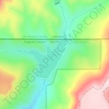
Name: Lake Maloya topographic map, elevation, terrain.
Location: Lake Maloya, Colfax County, New Mexico, United States (36.98369 -104.37889 36.99561 -104.36708)
Average elevation: 7,831 ft
Minimum elevation: 7,356 ft
Maximum elevation: 8,553 ft
Colfax County trails, hiking, mountain biking, running and outdoor activities
Make a donation
Gear up for your next adventure:
As an Amazon Associate, this site earns from qualifying purchases at no extra cost to you.
Other topographic maps
Click on a map to view its topography, its elevation and its terrain.
Make a donation
Gear up for your next adventure:
As an Amazon Associate, this site earns from qualifying purchases at no extra cost to you.
Apache Spring
United States > New Mexico > Colfax County > Val Verde Ski Area
Average elevation: 9,731 ft