Geolocate

Marcahuasi topographic map

Click on the map to display elevation.

About this map

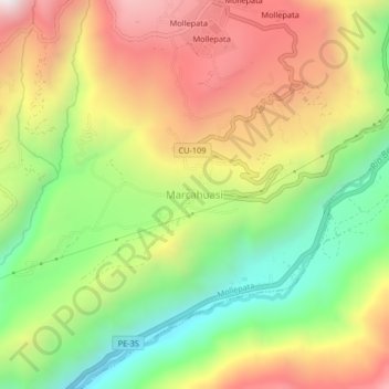
Name: Marcahuasi topographic map, elevation, terrain.

Location: Marcahuasi, Mollepata, Province of Anta, Cusco, Peru (-13.55062 -72.55073 -13.51062 -72.51073)

Average elevation: 7,999 ft

Minimum elevation: 6,240 ft

Maximum elevation: 9,931 ft

Other topographic maps

Click on a map to view its topography, its elevation and its terrain.

Machu Picchu

Peru > Cusco > Machupicchu

Average elevation: 7,306 ft

Mosoc Llacta

Peru > Cusco

Average elevation: 12,575 ft

Pisac

Peru > Cusco

Average elevation: 12,451 ft

Yuncaypata

Peru > Cusco

Average elevation: 12,228 ft

Vilcabamba

Peru > Cusco

Vilcabamba District is one of fourteen districts of the La Convención Province in the Cusco Region in Peru. The capital of the province is the Centro Poblado Lucma, which has an elevation of 2,943 metres (9,656 ft). Vitcos was an important city of the Neo-Inca State (1537-1572). Its ruins are now preserved as…

Average elevation: 9,088 ft

San Salvador

Peru > Cusco

Average elevation: 12,497 ft

Province of Acomayo

Peru > Cusco

Average elevation: 12,785 ft

Province of Quispicanchis

Peru > Cusco

Average elevation: 9,580 ft

Province of Paruro

Peru > Cusco

The provincial capital of Paruro, with population of 3,855, lies at 3,057 meters (10,032 ft) altitude. Two and a half hours by bus from Cusco, in the bottom of a deep valley, it is bordered on one side by the Rio Paruro, a feeder of the Apurímac River. A number of small Inca and pre-Inca ruins are in the…

Average elevation: 12,530 ft

Province of Paucartambo

Peru > Cusco

Average elevation: 9,209 ft

Urubamba

Peru > Cusco

Average elevation: 9,744 ft

Mollepata

Peru > Cusco > Mollepata

Average elevation: 11,732 ft

gorge

Peru > Cusco > Coporaque

Average elevation: 13,914 ft

Yanama

Peru > Cusco > Santa Teresa

Average elevation: 10,741 ft

Rio Aquascalientes

Peru > Cusco > Machupicchu > Machupicchu Pueblo

Average elevation: 8,668 ft

Gear up for your next adventure:

📚USA Hiking Guide Books - Top trail guides and map books
🧤Tactile Hiking Gloves - Keep hands warm while operating GPS and smartphone screens
🪑Ultralight Camp Chairs - Portable seating for resting after a long day of mapping
🧯Portable Fire Pit - Compact fire pit for camping spots
🪶Thermal Camp Blanket - Extra warmth for cold nights

As an Amazon Associate, this site earns from qualifying purchases at no extra cost to you.