
Make a donation
Gear up for your next adventure:
As an Amazon Associate, this site earns from qualifying purchases at no extra cost to you.
Landmannalaugar topographic map
Click on the map to display elevation.
Make a donation
Gear up for your next adventure:
As an Amazon Associate, this site earns from qualifying purchases at no extra cost to you.
About this map
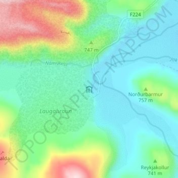
Name: Landmannalaugar topographic map, elevation, terrain.
Average elevation: 2,211 ft
Minimum elevation: 1,929 ft
Maximum elevation: 2,969 ft
Make a donation
Gear up for your next adventure:
As an Amazon Associate, this site earns from qualifying purchases at no extra cost to you.
Other topographic maps
Click on a map to view its topography, its elevation and its terrain.
Hekla
L'Hekla est un volcan situé dans le sud de l'Islande, dans les Hautes Terres, et culmine à 1 488 mètres d'altitude. Il se situe à environ 50 km au nord-est du village de Hvolsvöllur. Il est l'un des volcans les plus actifs d'Islande avec plus de 20 éruptions depuis 874.
Average elevation: 3,720 ft