
Make a donation
Gear up for your next adventure:
As an Amazon Associate, this site earns from qualifying purchases at no extra cost to you.
Distrik Kona topographic map
Click on the map to display elevation.
Make a donation
Gear up for your next adventure:
As an Amazon Associate, this site earns from qualifying purchases at no extra cost to you.
About this map
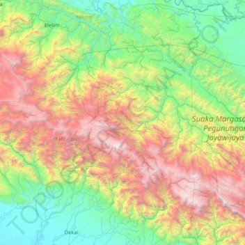
Name: Distrik Kona topographic map, elevation, terrain.
Location: Distrik Kona, Highland Papua, Western New Guinea, Indonesia (-4.98882 139.05616 -3.58882 140.45616)
Average elevation: 4,308 ft
Minimum elevation: 39 ft
Maximum elevation: 15,318 ft
Make a donation
Gear up for your next adventure:
As an Amazon Associate, this site earns from qualifying purchases at no extra cost to you.
Other topographic maps
Click on a map to view its topography, its elevation and its terrain.
Yahukimo
Yahukimo Regency is located in Highland Papua Province, Indonesia. Its geography consists mostly of mountainous areas and highlands. The regency has mountainous terrain and dense forests, with altitudes varying from lowlands to high mountains. This hilly topography makes access to some areas difficult and…
Average elevation: 4,331 ft
Make a donation
Gear up for your next adventure:
As an Amazon Associate, this site earns from qualifying purchases at no extra cost to you.
Make a donation
Gear up for your next adventure:
As an Amazon Associate, this site earns from qualifying purchases at no extra cost to you.
Make a donation
Gear up for your next adventure:
As an Amazon Associate, this site earns from qualifying purchases at no extra cost to you.