
Make a donation
Gear up for your next adventure:
As an Amazon Associate, this site earns from qualifying purchases at no extra cost to you.
Oberon topographic map
Click on the map to display elevation.
Make a donation
Gear up for your next adventure:
As an Amazon Associate, this site earns from qualifying purchases at no extra cost to you.
About this map
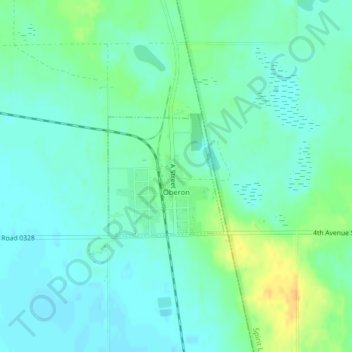
Name: Oberon topographic map, elevation, terrain.
Location: Oberon, Benson County, North Dakota, United States (47.91960 -99.21187 47.92900 -99.19854)
Average elevation: 1,555 ft
Minimum elevation: 1,526 ft
Maximum elevation: 1,621 ft
Benson County trails, hiking, mountain biking, running and outdoor activities
Make a donation
Gear up for your next adventure:
As an Amazon Associate, this site earns from qualifying purchases at no extra cost to you.
Other topographic maps
Click on a map to view its topography, its elevation and its terrain.
White Horse Hill National Game Preserve
United States > North Dakota > Benson County > Fort Totten
Average elevation: 1,545 ft