
Challis topographic map
Click on the map to display elevation.
Challis
Challis is located at 44°30′15″N 114°13′42″W / 44.50417°N 114.22833°W / 44.50417; -114.22833 (44.504260, -114.228279), at an elevation of 5,253 feet (1,601 m) above sea level.
About this map
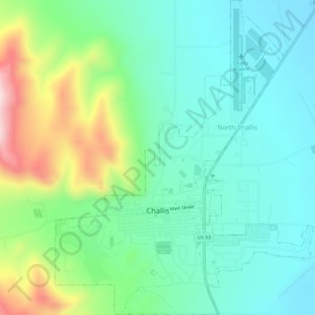
Name: Challis topographic map, elevation, terrain.
Location: Challis, Custer County, Idaho, United States (44.49235 -114.24897 44.53080 -114.20465)
Average elevation: 5,335 ft
Minimum elevation: 4,948 ft
Maximum elevation: 6,339 ft
Custer County trails, hiking, mountain biking, running and outdoor activities
Other topographic maps
Click on a map to view its topography, its elevation and its terrain.
Sawtooth Range
United States > Idaho > Custer County
The Sawtooth Range is a mountain range of the Rocky Mountains in central Idaho, United States, reaching a maximum elevation of 10,751 feet (3,277 m) at the summit of Thompson Peak. It encompasses an area of 678 square miles (1,756 km2) spanning parts of Custer, Boise, Blaine, and Elmore counties, and is…
Average elevation: 9,058 ft
Redfish Lake
United States > Idaho > Custer County
The surface elevation of Redfish Lake is 6,547 feet (1,996 m) above sea level. The lake is 4.5 miles (7.2 km) long and 0.72 miles (1.2 km) wide, with a maximum depth of 387 feet (118 m), and 11 miles (18 km) of shoreline. The actual trail around the lake is 17.5 miles (28 km) in length.
Average elevation: 7,034 ft
Edith Lake
United States > Idaho > Custer County
With a surface elevation of 8,660 feet (2,640 m) above sea level, Sawtooth Lake often remains frozen into early summer.
Average elevation: 8,819 ft