
Make a donation
Gear up for your next adventure:
As an Amazon Associate, this site earns from qualifying purchases at no extra cost to you.
Lower Stanley topographic map
Click on the map to display elevation.
Make a donation
Gear up for your next adventure:
As an Amazon Associate, this site earns from qualifying purchases at no extra cost to you.
About this map
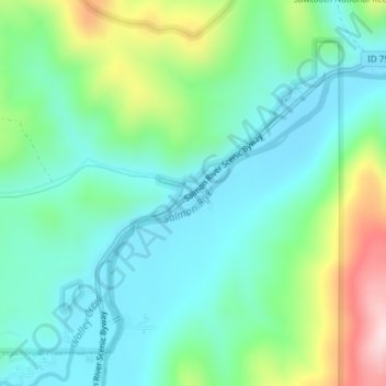
Name: Lower Stanley topographic map, elevation, terrain.
Location: Lower Stanley, Custer County, Idaho, 83278, United States (44.22230 -114.92986 44.24230 -114.90986)
Average elevation: 6,509 ft
Minimum elevation: 6,181 ft
Maximum elevation: 7,398 ft
Make a donation
Gear up for your next adventure:
As an Amazon Associate, this site earns from qualifying purchases at no extra cost to you.
Other topographic maps
Click on a map to view its topography, its elevation and its terrain.
Challis
United States > Idaho > Custer County
Challis is located at 44°30′15″N 114°13′42″W / 44.50417°N 114.22833°W / 44.50417; -114.22833 (44.504260, -114.228279), at an elevation of 5,253 feet (1,601 m) above sea level.
Average elevation: 5,335 ft
Mackay
United States > Idaho > Custer County
Mackay is located at 43°54′43″N 113°36′49″W / 43.91194°N 113.61361°W / 43.91194; -113.61361 (43.911880, -113.613669), at an elevation of 5,905 feet (1,800 m).
Average elevation: 5,942 ft
Stanley
United States > Idaho > Custer County
Stanley is located at 44°13′0″N 114°56′16″W / 44.21667°N 114.93778°W / 44.21667; -114.93778 (44.216698, -114.937814), at an elevation of 6,253 feet (1,906 m) above sea level
Average elevation: 6,335 ft
Edith Lake
United States > Idaho > Custer County
With a surface elevation of 8,660 feet (2,640 m) above sea level, Sawtooth Lake often remains frozen into early summer.
Average elevation: 8,819 ft
Make a donation
Gear up for your next adventure:
As an Amazon Associate, this site earns from qualifying purchases at no extra cost to you.
Stanley
United States > Idaho > Custer County
In latitude and elevation, Stanley's weather station is a near-perfect twin of the station at the summit of Mt. Washington in New Hampshire. But although both are quite cold, their climates are very different.
Average elevation: 6,335 ft
Make a donation
Gear up for your next adventure:
As an Amazon Associate, this site earns from qualifying purchases at no extra cost to you.
Mackay
United States > Idaho > Custer County
Mackay is located at 43°54′43″N 113°36′49″W / 43.91194°N 113.61361°W / 43.91194; -113.61361 (43.911880, -113.613669), at an elevation of 5,905 feet (1,800 m).
Average elevation: 5,942 ft
Make a donation
Gear up for your next adventure:
As an Amazon Associate, this site earns from qualifying purchases at no extra cost to you.
Redfish Lake
United States > Idaho > Custer County
The surface elevation of Redfish Lake is 6,547 feet (1,996 m) above sea level. The lake is 4.5 miles (7.2 km) long and 0.72 miles (1.2 km) wide, with a maximum depth of 387 feet (118 m), and 11 miles (18 km) of shoreline. The actual trail around the lake is 17.5 miles (28 km) in length.
Average elevation: 7,034 ft