
Make a donation
Gear up for your next adventure:
As an Amazon Associate, this site earns from qualifying purchases at no extra cost to you.
Sulzbach topographic map
Click on the map to display elevation.
Make a donation
Gear up for your next adventure:
As an Amazon Associate, this site earns from qualifying purchases at no extra cost to you.
About this map
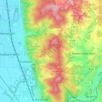
Name: Sulzbach topographic map, elevation, terrain.
Average elevation: 640 ft
Minimum elevation: 308 ft
Maximum elevation: 1,201 ft
Make a donation
Gear up for your next adventure:
As an Amazon Associate, this site earns from qualifying purchases at no extra cost to you.
Other topographic maps
Click on a map to view its topography, its elevation and its terrain.
Oberflockenbach
Deutschland > Baden-Württemberg > Rhein-Neckar-Kreis > Weinheim > Oberflockenbach
Average elevation: 1,056 ft
Ritschweier
Deutschland > Baden-Württemberg > Rhein-Neckar-Kreis > Weinheim
Ritschweier befindet sich in einem in Ost-West-Richtung verlaufenden Tal im westlichsten Bereich des kristallinen Odenwaldes, nur durch einen Höhenzug von der etwa drei Kilometer entfernt verlaufenden Bergstraße getrennt. Die Gemarkung befindet sich in einer Höhenlage zwischen 228 und 324 m ü. NN und…
Average elevation: 873 ft
Steinklingen
Deutschland > Baden-Württemberg > Rhein-Neckar-Kreis > Weinheim > Oberflockenbach
Average elevation: 1,138 ft
Make a donation
Gear up for your next adventure:
As an Amazon Associate, this site earns from qualifying purchases at no extra cost to you.
Rittenweier
Deutschland > Baden-Württemberg > Rhein-Neckar-Kreis > Weinheim > Rittenweier
Average elevation: 981 ft