Geolocate

Powell topographic map

Click on the map to display elevation.

About this map

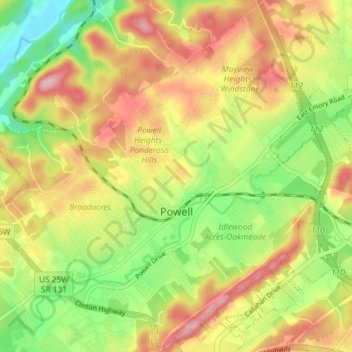
Name: Powell topographic map, elevation, terrain.

Location: Powell, Knox County, East Tennessee, Tennessee, 37849, United States (36.00868 -84.06949 36.06659 -83.99680)

Average elevation: 1,079 ft

Minimum elevation: 814 ft

Maximum elevation: 1,348 ft

Knox County trails, hiking, mountain biking, running and outdoor activities

Other topographic maps

Click on a map to view its topography, its elevation and its terrain.

Happy Acres

United States > Tennessee > Knox County

Average elevation: 1,056 ft

Corryton

United States > Tennessee > Knox County

Average elevation: 1,047 ft

Lonsdale

United States > Tennessee > Knox County > Knoxville

Average elevation: 1,007 ft

Ponderosa Hills

United States > Tennessee > Knox County > Powell

Average elevation: 1,099 ft

House Mountain

United States > Tennessee > Knox County

House Mountain is a mountain located in Corryton, Tennessee, United States, about 8 miles (13 km) northeast of Knoxville. Rising to an elevation of 2,064 feet (629 m) above sea level, House Mountain is the highest point in Knox County.

Average elevation: 1,293 ft

Pleasant Hills

United States > Tennessee > Knox County > Knoxville

Average elevation: 1,086 ft

Cherokee Ridge

United States > Tennessee > Knox County

Average elevation: 1,102 ft

Fair Oaks

United States > Tennessee > Knox County > Knoxville

Average elevation: 1,089 ft

Ridgedale

United States > Tennessee > Knox County > Knoxville

Average elevation: 1,102 ft

Murphy Hills

United States > Tennessee > Knox County

Average elevation: 1,129 ft

Carter

United States > Tennessee > Knox County

Average elevation: 961 ft

Mayview Heights

United States > Tennessee > Knox County > Powell

Average elevation: 1,086 ft

Norwood

United States > Tennessee > Knox County > Knoxville

Average elevation: 1,076 ft

Peters Mill

United States > Tennessee > Knox County

Average elevation: 919 ft

Dante

United States > Tennessee > Knox County > Knoxville

Average elevation: 1,089 ft

Treeville

United States > Tennessee > Knox County

Average elevation: 1,047 ft

Ten Mile

United States > Tennessee > Knox County > Knoxville

Average elevation: 955 ft

Ponderosa Hills

United States > Tennessee > Knox County > Powell

Average elevation: 1,099 ft

Corryton

United States > Tennessee > Knox County

Average elevation: 1,047 ft

Fair Oaks

United States > Tennessee > Knox County > Knoxville

Average elevation: 1,089 ft

Tennesse Rugby Park

United States > Tennessee > Knox County

Average elevation: 1,004 ft

Buffat Heights

United States > Tennessee > Knox County > Knoxville

Average elevation: 994 ft

Dead Horse Lake

United States > Tennessee > Knox County > Knoxville

Average elevation: 971 ft

Whittle Springs

United States > Tennessee > Knox County > Knoxville

Average elevation: 1,020 ft

Knoxville

United States > Tennessee > Knox County > Knoxville

Average elevation: 997 ft

Ten Mile

United States > Tennessee > Knox County > Knoxville

Average elevation: 955 ft

Shannondale

United States > Tennessee > Knox County > Knoxville

Average elevation: 1,096 ft

Treeville

United States > Tennessee > Knox County

Average elevation: 1,047 ft

High Bluff

United States > Tennessee > Knox County

Average elevation: 978 ft

Melton Hill Park

United States > Tennessee > Knox County

Average elevation: 883 ft

Vestal

United States > Tennessee > Knox County > Knoxville > Vestal

Average elevation: 932 ft

Gear up for your next adventure:

📻Weather Alert Radios - Stay informed of storm risks while off-the-grid
🧭Map Reading Tools - Tools and kits for map navigation
👟Men's Trail Runners - Lightweight footwear for fast-paced exploration and light hiking
🪶Trail Camera - Capture wildlife on your hikes
🔪Outdoor Multitools - Essential survival tools for gear repair and field use

As an Amazon Associate, this site earns from qualifying purchases at no extra cost to you.