Geolocate

New River topographic map

Interactive map

Click on the map to display elevation.

About this map

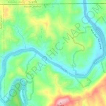
Name: New River topographic map, elevation, terrain.

Location: New River, Alleghany County, North Carolina, 28663, United States (36.54609 -81.35499 36.57492 -81.31649)

Average elevation: 2,635 ft

Minimum elevation: 2,434 ft

Maximum elevation: 3,045 ft

On its journey through the New River Gorge, the New River passes through an extensive geological formation. Emergent rocks and rock outcrops are found to provide diverse habitat producing rich and abundant flora and fauna species. In the gorge, there is typically a 1000 feet difference in elevation between the river bottom and the adjacent plateau. The New River dissects all physiographic provinces of the Appalachian Mountains, and therefore is believed to be a corridor facilitating the movement of southern plant and animal species into West Virginia. In addition to serving as a refuge for some species, New River Gorge provides a geographical barrier that limits the east-west distribution of other species.

Wikipedia (CC-BY-SA 3.0)

Other topographic maps

Click on a map to view its topography, its elevation and its terrain.

Sparta

United States > North Carolina > Alleghany County

Sparta, Alleghany County, North Carolina, 28675, United States

Average elevation: 2,930 ft

Camp Cheerio Dam

United States > North Carolina > Alleghany County

Camp Cheerio Dam, Alleghany County, North Carolina, 28668, United States

Average elevation: 2,667 ft

Glade Valley

United States > North Carolina > Alleghany County

Glade Valley, Alleghany County, North Carolina, 28627, United States

Average elevation: 2,746 ft

Piney Creek

United States > North Carolina > Alleghany County

Piney Creek, Alleghany County, North Carolina, 28663, United States

Average elevation: 2,753 ft

Little River

United States > North Carolina > Alleghany County > Sparta

Little River, Sparta, Alleghany County, North Carolina, 28675, United States

Average elevation: 2,838 ft

Topia

United States > North Carolina > Alleghany County > Topia

Topia, Alleghany County, North Carolina, 28663, United States

Average elevation: 2,723 ft

Roaring Gap

United States > North Carolina > Alleghany County

Roaring Gap, Alleghany County, North Carolina, 28668, United States

Average elevation: 2,756 ft

Ennice

United States > North Carolina > Alleghany County

Ennice, Alleghany County, North Carolina, 28623, United States

Average elevation: 2,605 ft

Laurel Springs

United States > North Carolina > Alleghany County

Laurel Springs, Alleghany County, North Carolina, 28644, United States

Average elevation: 2,930 ft