
Make a donation
Gear up for your next adventure:
As an Amazon Associate, this site earns from qualifying purchases at no extra cost to you.
High Meadows Estates topographic map
Click on the map to display elevation.
Make a donation
Gear up for your next adventure:
As an Amazon Associate, this site earns from qualifying purchases at no extra cost to you.
About this map
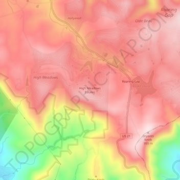
Name: High Meadows Estates topographic map, elevation, terrain.
Average elevation: 2,746 ft
Minimum elevation: 1,873 ft
Maximum elevation: 3,143 ft
Alleghany County trails, hiking, mountain biking, running and outdoor activities
Make a donation
Gear up for your next adventure:
As an Amazon Associate, this site earns from qualifying purchases at no extra cost to you.
Other topographic maps
Click on a map to view its topography, its elevation and its terrain.
New River
United States > North Carolina > Alleghany County
On its journey through the New River Gorge, the New River passes through an extensive geological formation. Emergent rocks and rock outcrops are found to provide diverse habitat producing rich and abundant flora and fauna species. In the gorge, there is typically a 1000 feet difference in elevation between the…
Average elevation: 2,635 ft