
Tarvisio topographic map
Click on the map to display elevation.
About this map
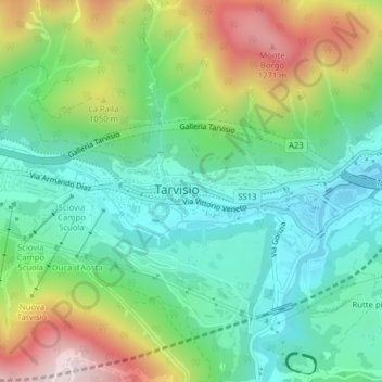
Name: Tarvisio topographic map, elevation, terrain.
Location: Tarvisio, Udine, Friuli-Venezia Giulia, Italy (46.50493 13.57946 46.50540 13.58008)
Average elevation: 2,959 ft
Minimum elevation: 2,274 ft
Maximum elevation: 4,334 ft
Other topographic maps
Click on a map to view its topography, its elevation and its terrain.
Sella Nevea
Italy > Friuli-Venezia Giulia > Udine > Chiusaforte
Sella Nevea (Friulian: Nevee, German: Neveasattel, Slovene: Na Žlebeh), at an altitude of 1,195 m (3,921 ft), is a high mountain pass in the Julian Alps, in the Friuli Venezia Giulia region of northeast Italy. Sella Nevea also lends its name to a frazione of the Chiusaforte municipality and the nearby…
Average elevation: 5,069 ft
Palazzolo dello Stella
Italy > Friuli-Venezia Giulia > Udine > Palazzolo dello Stella
Average elevation: 3 ft
Cesclans
Italy > Friuli-Venezia Giulia > Udine > Cavazzo Carnico > Cesclans
Average elevation: 1,457 ft
Trinco / Trinko
Italy > Friuli-Venezia Giulia > Udine > Drenchia > Drenchia / Dreka > Trinco / Trinko
Average elevation: 2,434 ft