Geolocate

Percoto topographic map

Click on the map to display elevation.

About this map

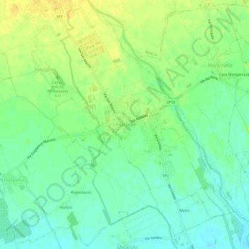
Name: Percoto topographic map, elevation, terrain.

Location: Percoto, Pavia di Udine, Udine, Friuli-Venezia Giulia, 33050, Italy (45.95437 13.30233 45.99437 13.34233)

Average elevation: 187 ft

Minimum elevation: 148 ft

Maximum elevation: 226 ft

Other topographic maps

Click on a map to view its topography, its elevation and its terrain.

Aiello del Friuli

Italy > Friuli-Venezia Giulia > Udine

Average elevation: 52 ft

Sutrio

Italy > Friuli-Venezia Giulia > Udine

Average elevation: 2,943 ft

Tarvisio

Italy > Friuli-Venezia Giulia > Udine

Average elevation: 2,959 ft

Tagliamento

Italy > Friuli-Venezia Giulia > Udine > Invillino

Average elevation: 2,244 ft

Aquileia

Italy > Friuli-Venezia Giulia > Udine

Average elevation: 0 ft

Amaro

Italy > Friuli-Venezia Giulia > Udine > Amaro

Average elevation: 2,044 ft

Gear up for your next adventure:

🏥Hiking First Aid Kits - Comprehensive medical kits for remote trail injuries
🪵Folding Camp Saw - Compact saw for wood and campsite work
🪶Camp Gear Gift Set - Perfect gift bundle for outdoor fans
😴Insulated Sleeping Pads - Compact and warm pads for high-elevation camping
🦶Hiking Gaiters - Keep debris and water out of your boots

As an Amazon Associate, this site earns from qualifying purchases at no extra cost to you.