
Make a donation
Gear up for your next adventure:
As an Amazon Associate, this site earns from qualifying purchases at no extra cost to you.
Lornís topographic map
Click on the map to display elevation.
Make a donation
Gear up for your next adventure:
As an Amazon Associate, this site earns from qualifying purchases at no extra cost to you.
About this map
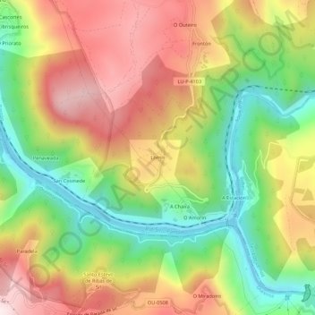
Name: Lornís topographic map, elevation, terrain.
Average elevation: 1,385 ft
Minimum elevation: 420 ft
Maximum elevation: 2,405 ft
Make a donation
Gear up for your next adventure:
As an Amazon Associate, this site earns from qualifying purchases at no extra cost to you.
Other topographic maps
Click on a map to view its topography, its elevation and its terrain.
Sober
España > Galicia > Tierra de Lemos
El municipio de Sober tiene una superficie de 133,35 km² y se encuentra en la comarca de Tierra de Lemos, en el sur de la provincia de Lugo, entre los cursos de los ríos Cabe y Sil, que hacen de frontera física por el oeste y sur, respectivamente. El término municipal está atravesado por la carretera…
Average elevation: 1,690 ft
A Pobra do Brollón
España > Galicia > Tierra de Lemos
El municipio se encuentra ubicado entre el valle de Lemos y la Sierra del Caurel. El relieve se caracteriza por su topografía montañosa, de fuertes elevaciones que van descendiendo de este a oeste. Destacan montes como el Alto da Veneira (1164 metros), el Alto da Serra (1141 metros), O Petón (958 metros), A…
Average elevation: 1,716 ft
Monforte de Lemos
España > Galicia > Tierra de Lemos
El municipio de Monforte de Lemos se encuentra en el sur de la provincia de Lugo, en el interior de la comunidad autónoma de Galicia. Está situado en el valle de Lemos, en el curso del río Cabe, y tiene una superficie de 199,52 km². Sus coordenadas son 42°31′N 7°30′O / 42.517, -7.500. La…
Average elevation: 1,453 ft
Bóveda
España > Galicia > Tierra de Lemos
Se trata de una zona de transición entre el Valle de Lemos y la montaña. Tiene un relieve montañoso, llegando a alcanzar los 689 metros en su zona occidental, en el monte Couso. El resto del municipio tiene una altitud media de 450 metros.
Average elevation: 1,552 ft
Make a donation
Gear up for your next adventure:
As an Amazon Associate, this site earns from qualifying purchases at no extra cost to you.
Pantón
España > Galicia > Tierra de Lemos
El relieve del término municipal de Pantón está caracterizado por las depresiones de los ríos Cabe, Miño y Sil, entre las que se alzan los Montes de San Paio, que alcanzan los 686 metros de altitud. La mayor altura del territorio es el monte Pena Pombeira (703 metros), situado al sur, cerca del cañón…
Average elevation: 1,457 ft
O Saviñao
España > Galicia > Tierra de Lemos
El municipio de Saviñao está enclavado en la Ribeira Sacra, dentro de la Comarca de Tierra de Lemos, situado en el sur de la provincia de Lugo, limita con los municipios de: al norte con Paradela y Taboada, al sur con Pantón, al este con Pantón, Monforte de Lemos y Bóveda y oeste con Taboada y Chantada.…
Average elevation: 1,762 ft
Make a donation
Gear up for your next adventure:
As an Amazon Associate, this site earns from qualifying purchases at no extra cost to you.
Make a donation
Gear up for your next adventure:
As an Amazon Associate, this site earns from qualifying purchases at no extra cost to you.
Make a donation
Gear up for your next adventure:
As an Amazon Associate, this site earns from qualifying purchases at no extra cost to you.
Canedo
España > Galicia > Tierra de Lemos > A Pobra do Brollón
Se encuentra en la zona septentrional del municipio de Puebla del Brollón. La altitud aumenta de oeste a este, donde se encuentran los dos puntos más altos: Alto do Pedregal (664,8 m) y Pico do Santo (644,7 m).
Average elevation: 1,617 ft
Make a donation
Gear up for your next adventure:
As an Amazon Associate, this site earns from qualifying purchases at no extra cost to you.
Make a donation
Gear up for your next adventure:
As an Amazon Associate, this site earns from qualifying purchases at no extra cost to you.
Make a donation
Gear up for your next adventure:
As an Amazon Associate, this site earns from qualifying purchases at no extra cost to you.
Make a donation
Gear up for your next adventure:
As an Amazon Associate, this site earns from qualifying purchases at no extra cost to you.
Pantón
España > Galicia > Tierra de Lemos
El relieve del término municipal de Pantón está caracterizado por las depresiones de los ríos Cabe, Miño y Sil, entre las que se alzan los Montes de San Paio, que alcanzan los 686 metros de altitud. La mayor altura del territorio es el monte Pena Pombeira (703 metros), situado al sur, cerca del cañón…
Average elevation: 1,457 ft
Monforte de Lemos
España > Galicia > Tierra de Lemos
El municipio de Monforte de Lemos se encuentra en el sur de la provincia de Lugo, en el interior de la comunidad autónoma de Galicia. Está situado en el valle de Lemos, en el curso del río Cabe, y tiene una superficie de 199,52 km². Sus coordenadas son 42°31′N 7°30′O / 42.517, -7.500. La…
Average elevation: 1,453 ft
Make a donation
Gear up for your next adventure:
As an Amazon Associate, this site earns from qualifying purchases at no extra cost to you.
Bóveda
España > Galicia > Tierra de Lemos
Se trata de una zona de transición entre el Valle de Lemos y la montaña. Tiene un relieve montañoso, llegando a alcanzar los 689 metros en su zona occidental, en el monte Couso. El resto del municipio tiene una altitud media de 450 metros.
Average elevation: 1,552 ft