Geolocate

Dookie topographic map

Click on the map to display elevation.

About this map

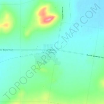
Name: Dookie topographic map, elevation, terrain.

Location: Dookie, City of Greater Shepparton, Victoria, 3546, Australia (-36.34834 145.66742 -36.30834 145.70742)

Average elevation: 545 ft

Minimum elevation: 436 ft

Maximum elevation: 892 ft

Other topographic maps

Click on a map to view its topography, its elevation and its terrain.

City of Melbourne

Australia > Victoria

Melbourne's topography is characterized by a diverse landscape that transitions from flat coastal plains to rolling hills and mountainous regions. The city is situated at the northern end of Port Phillip Bay, where the terrain is predominantly flat, facilitating urban development. As one moves eastward, the…

Average elevation: 59 ft

Melbourne

Australia > Victoria

Melbourne is also prone to isolated convective showers forming when a cold pool crosses the state, especially if there is considerable daytime heating. These showers are often heavy and can include hail, squalls, and significant drops in temperature, but they often pass through very quickly with a rapid…

Average elevation: 607 ft

Eltham District

Australia > Victoria > Melbourne

Average elevation: 279 ft

Melbourne

Australia > Victoria

Melbourne is also prone to isolated convective showers forming when a cold pool crosses the state, especially if there is considerable daytime heating. These showers are often heavy and can include hail, squalls, and significant drops in temperature, but they often pass through very quickly with a rapid…

Average elevation: 607 ft

Gippsland

Australia > Victoria

Average elevation: 896 ft

Mount Martha

Australia > Victoria

Average elevation: 131 ft

Collingwood

Australia > Victoria

Collingwood's topography is mostly flat, but a prominent slope extends from Hoddle Street up to Smith Street, and also along sections of Hoddle Street.

Average elevation: 98 ft

Highton

Australia > Victoria

Average elevation: 171 ft

Shire of East Gippsland

Australia > Victoria

Average elevation: 1,480 ft

Howqua River

Australia > Victoria

Average elevation: 2,536 ft

Fitzroy

Australia > Victoria > Melbourne

Fitzroy's topography is flat. It is laid out in grid plan and is characterised by a fairly tightly spaced rectangular grid of medium-sized streets, with many of its narrow streets and back lanes facilitating only one-way traffic. Its built form is a legacy of its early history when a mixture of land uses was…

Average elevation: 115 ft

Rye

Australia > Victoria

Average elevation: 36 ft

Echuca

Australia > Victoria

Average elevation: 328 ft

Traralgon

Australia > Victoria

Average elevation: 174 ft

Mount Eliza

Australia > Victoria > Melbourne

Average elevation: 197 ft

City of Whitehorse

Australia > Victoria

Average elevation: 335 ft

Castlemaine

Australia > Victoria

The Castlemaine goldfields' legendary prosperity raised expectations of Castlemaine becoming Victoria's second city. That is reflected in imposing buildings erected in the town's first few years. Though the rich alluvial diggings were largely exhausted within 15–20 years causing the town's population to…

Average elevation: 1,047 ft

Mount Buller

Australia > Victoria

Due to its far south-western location in the alpine region, Mount Buller is more susceptible to cold airmasses which allow it to record some of the lowest maximum temperatures and daytime readings in the country, despite being considerably lower in elevation than other mountain sites to the north-east. On 5…

Average elevation: 2,703 ft

Warrnambool

Australia > Victoria

Average elevation: 62 ft

Parkville

Australia > Victoria

Average elevation: 112 ft

Bairnsdale

Australia > Victoria

A comprehensive geological survey of Victoria's Great Dividing Range reveals a distinct north-south alignment in its bedrock, a vestige of the bygone epochs of plate tectonics. This enduring geological framework, coupled with ongoing tectonic activity, contributes to the dynamic topography witnessed in the…

Average elevation: 82 ft

Frankston

Australia > Victoria

Olivers Hill is the most prominent elevation in Frankston which rises to 55 metres above sea level (180 feet) at its highest point in the suburb. Its origins date to approximately 415 to 360 million years ago. Its base is Mount Eliza Granite dating from the Devonian period, which was covered in lava tuffs in…

Average elevation: 131 ft

Creswick

Australia > Victoria

Average elevation: 1,539 ft

Shire of Yarra Ranges

Australia > Victoria

Average elevation: 1,444 ft

San Remo

Australia > Victoria

Average elevation: 30 ft

Rubicon

Australia > Victoria

Average elevation: 2,421 ft

Durham Lead Bushland Reserve

Australia > Victoria

Average elevation: 1,247 ft

Bullarto

Australia > Victoria

Average elevation: 2,411 ft

Bungal

Australia > Victoria

Average elevation: 1,358 ft

Taggerty

Australia > Victoria

Average elevation: 1,325 ft

West Melbourne

Australia > Victoria

Average elevation: 26 ft

Point Cook

Australia > Victoria > Melbourne

Average elevation: 26 ft

Dandenong Ranges National Park - Ferntree Gully

Australia > Victoria > Montrose

The topography consists of a series of ridges dissected by deeply cut streams. Sheltered gullies in the south of the range are home to temperate rain forest, fern gullies and Mountain Ash forest Eucalyptus regnans, whereas the drier ridges and exposed northern slopes are covered by dry sclerophyll forest of…

Average elevation: 1,132 ft

Phillip Island

Australia > Victoria > Ventnor

Average elevation: 16 ft

Lerderderg State Park

Australia > Victoria

Average elevation: 1,506 ft

Clayton

Australia > Victoria > Melbourne

Average elevation: 259 ft

Boronia

Australia > Victoria > Melbourne

Average elevation: 453 ft

Fitzroy North

Australia > Victoria > Melbourne

Average elevation: 125 ft

Mount Waverley District

Australia > Victoria

Average elevation: 328 ft

Grampians

Australia > Victoria

Average elevation: 495 ft

Port Melbourne

Australia > Victoria > Melbourne

Average elevation: 13 ft

Glen Iris

Australia > Victoria

Average elevation: 151 ft

Heidelberg

Australia > Victoria > Melbourne

Average elevation: 161 ft

Glen Waverley

Australia > Victoria

Average elevation: 338 ft

Warburton

Australia > Victoria

Average elevation: 1,722 ft

Yarra Bend Park

Australia > Victoria > Melbourne

Average elevation: 102 ft

Grampians National Park

Australia > Victoria

Mount William is known within the gliding community for the "Grampians Wave", a weather phenomenon that sometimes enables glider pilots to reach extreme altitudes of the order of 28,000 ft (8,500 m). This predominantly occurs during the months of May, June, September and October when strong westerly winds flow…

Average elevation: 860 ft

Barwon Heads

Australia > Victoria

Average elevation: 13 ft

Ballarat North

Australia > Victoria

Average elevation: 1,542 ft

Bellarine District

Australia > Victoria > Wallington

Average elevation: 49 ft

Fitzroy Gardens

Australia > Victoria > Melbourne

Average elevation: 89 ft

Arawata

Australia > Victoria

Average elevation: 696 ft

Eumeralla

Australia > Victoria > Anglesea

Average elevation: 105 ft

Moorabool Reservoir

Australia > Victoria

Average elevation: 1,998 ft

Maldon

Australia > Victoria

Average elevation: 1,014 ft

Elwood

Australia > Victoria > Melbourne

Average elevation: 26 ft

Diamond Creek

Australia > Victoria

Average elevation: 246 ft

Berwick

Australia > Victoria > Harkaway

Average elevation: 190 ft

Kilmore

Australia > Victoria

Average elevation: 1,145 ft

Swifts Creek

Australia > Victoria

Average elevation: 2,156 ft

Shire of Mansfield

Australia > Victoria

Average elevation: 2,454 ft

City of Port Phillip

Australia > Victoria

Average elevation: 49 ft

Gellibrand

Australia > Victoria

Average elevation: 591 ft

Bellbrae

Australia > Victoria

Average elevation: 200 ft

Mount Eccles

Australia > Victoria

Average elevation: 587 ft

Mitta Mitta River

Australia > Victoria

Average elevation: 2,093 ft

Lake Glenmaggie

Australia > Victoria

Average elevation: 322 ft

Dergholm

Australia > Victoria

Average elevation: 430 ft

Marysville

Australia > Victoria

Average elevation: 2,677 ft

Wonga Park

Australia > Victoria

Average elevation: 299 ft

Eden Park

Australia > Victoria

Average elevation: 846 ft

Connewarre

Australia > Victoria

Average elevation: 33 ft

Mornington District

Australia > Victoria > Melbourne

Average elevation: 164 ft

Templestowe

Australia > Victoria > Melbourne

Gentle, rolling hills extend from east of the Yarra River flood plains, along Templestowe Road (towards the Eastern Freeway) for seven km (4.3 miles), to the north-east. The altitude of the plain above sea level is 50 m, and the topography is subdued and mostly flat; the hills are just below 60 m, the slopes…

Average elevation: 217 ft

Kalkallo

Australia > Victoria > Melbourne

Average elevation: 768 ft

Wollert

Australia > Victoria

Average elevation: 627 ft

Ruffey Lake Park

Australia > Victoria > Melbourne

Average elevation: 292 ft

Yarrawonga

Australia > Victoria

Average elevation: 423 ft

Mount Lonarch

Australia > Victoria

Average elevation: 1,404 ft

Oakleigh South

Australia > Victoria > Melbourne

A 2005 report called Livable Melbourne that was commissioned by The Age and conducted by Tract Consultants and ACIL Tasman, ranked Melbourne suburbs and assigned them scores on fourteen characteristics such as crime, CBD proximity, and traffic congestion. The report found that Oakleigh South had a very low…

Average elevation: 180 ft

Kaniva

Australia > Victoria

Average elevation: 446 ft

Richmond District

Australia > Victoria > Melbourne

Average elevation: 92 ft

Flinders

Australia > Victoria

Average elevation: 174 ft

Murchison North

Australia > Victoria

Average elevation: 397 ft

Wyndham Vale

Australia > Victoria > Werribee

Average elevation: 151 ft

Cockatoo

Australia > Victoria

Average elevation: 761 ft

Ringwood

Australia > Victoria

Average elevation: 417 ft

Lorne

Australia > Victoria

Average elevation: 528 ft

Shepparton District

Australia > Victoria > Shepparton

Average elevation: 371 ft

Horsham

Australia > Victoria

Horsham's topography is flat, approximately 128 metres (420 ft) above sea level. The central business district (CBD) is laid out in a grid plan south of the train line and is characterised by wide streets and several roundabouts. Firebrace Street, running north–south through the middle of the CBD is one of…

Average elevation: 423 ft

Moe

Australia > Victoria

Average elevation: 259 ft

Surrey Hills

Australia > Victoria > Melbourne

Average elevation: 315 ft

Greensborough

Australia > Victoria

Average elevation: 272 ft

Kyneton

Australia > Victoria

Average elevation: 1,654 ft

Omeo

Australia > Victoria

There are bus routes from Bright and Bairnsdale. The Bairnsdale bus runs weekdays, once both directions, and the Bright bus (Alps Link) timetable is less frequent in Summer and runs additional services during the ski season. Alps Link is the highest altitude public bus in Australia. The town sits at the…

Average elevation: 2,825 ft

Werribee

Australia > Victoria > Melbourne

Average elevation: 72 ft

Gear up for your next adventure:

🧭Map Reading Tools - Tools and kits for map navigation
🪶Paracord Bracelet - Survival bracelet with built‑in tools
🗺️NatGeo Topo Maps - High-quality waterproof printed topographic maps of US Parks
🪄Magnetic Compass - Accurate compass for navigation
🧢Sun Protection Hats - Wide-brimmed and UPF-rated hats for high-altitude sun safety

As an Amazon Associate, this site earns from qualifying purchases at no extra cost to you.