
Chatham topographic map
Click on the map to display elevation.
Chatham
The Passaic River, which rises at Millington Gorge in Long Hill Township and defines the Great Swamp, flows north along the eastern boundary of Chatham. A good crossing location, identified by Native Americans to early European settlers, figured significantly in the colonial history of the community. Fairmount Avenue ascends Long Hill perpendicularly from Main Street in the contemporary center of town to the highest elevation of the town among the Watchung Mountains. From there, one may see the lights of New York beyond the crest of the ridge hills of Summit and Short Hills. Water from artesian wells is stored at its crest to provide the drinking water for the community.
About this map
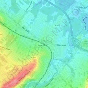
Name: Chatham topographic map, elevation, terrain.
Location: Chatham, Morris County, New Jersey, United States (40.72430 -74.39975 40.75521 -74.36307)
Average elevation: 249 ft
Minimum elevation: 167 ft
Maximum elevation: 463 ft
Morris County trails, hiking, mountain biking, running and outdoor activities
Other topographic maps
Click on a map to view its topography, its elevation and its terrain.
Kenvil
United States > New Jersey > Morris County > Roxbury Township > Succasunna
Average elevation: 784 ft
Washington Valley
United States > New Jersey > Morris County > Morris Township
Average elevation: 499 ft
Powder Mill Pond Dam
United States > New Jersey > Morris County > Parsippany-Troy Hills > Tabor
Average elevation: 584 ft
Parsippany
United States > New Jersey > Morris County > Parsippany-Troy Hills
Average elevation: 312 ft
Mooney Mountain Park
United States > New Jersey > Morris County > Roxbury Township
Average elevation: 1,070 ft
Lake Parsippany
United States > New Jersey > Morris County > Parsippany-Troy Hills
Average elevation: 305 ft
Schooleys Mountain
United States > New Jersey > Morris County > Washington Township
Average elevation: 961 ft
Mount Freedom
United States > New Jersey > Morris County > Randolph Township
Average elevation: 883 ft
Pleasant Valley
United States > New Jersey > Morris County > Mendham Township
Average elevation: 512 ft
Calais Crossroads
United States > New Jersey > Morris County > Randolph Township
Average elevation: 932 ft
Lower Montville
United States > New Jersey > Morris County > Montville Township
Average elevation: 276 ft
Parsippany
United States > New Jersey > Morris County > Parsippany-Troy Hills
Average elevation: 312 ft
Washington Corner
United States > New Jersey > Morris County > Mendham Township
Average elevation: 571 ft
Lake Hiawatha
United States > New Jersey > Morris County > Parsippany-Troy Hills
Average elevation: 249 ft
Rockaway Valley
United States > New Jersey > Morris County > Boonton Township
Average elevation: 594 ft
Roxbury Township
United States > New Jersey > Morris County > Roxbury Township
Average elevation: 866 ft
Floral Hill
United States > New Jersey > Morris County > Chatham Township > Floral Hill
Average elevation: 295 ft