
Make a donation
Gear up for your next adventure:
As an Amazon Associate, this site earns from qualifying purchases at no extra cost to you.
Invercargill City topographic map
Click on the map to display elevation.
Make a donation
Gear up for your next adventure:
As an Amazon Associate, this site earns from qualifying purchases at no extra cost to you.
About this map
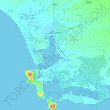
Name: Invercargill City topographic map, elevation, terrain.
Location: Invercargill City, Southland, New Zealand (-46.62559 168.19540 -46.32217 168.54278)
Average elevation: 36 ft
Minimum elevation: -7 ft
Maximum elevation: 774 ft
Make a donation
Gear up for your next adventure:
As an Amazon Associate, this site earns from qualifying purchases at no extra cost to you.
Other topographic maps
Click on a map to view its topography, its elevation and its terrain.
Sutherland Falls
New Zealand > Southland > Southland District > Fiordland Community
Average elevation: 3,301 ft
Glenham
New Zealand > Southland > Southland District > Waihopai Toetoe Community
Average elevation: 358 ft
Make a donation
Gear up for your next adventure:
As an Amazon Associate, this site earns from qualifying purchases at no extra cost to you.
Mount Mackenzie
New Zealand > Southland > Southland District > Fiordland Community
Average elevation: 3,839 ft
Oban
New Zealand > Southland > Southland District > Stewart Island / Rakiura Community
Average elevation: 75 ft
Misty River
New Zealand > Southland > Southland District > Fiordland Community
Average elevation: 1,240 ft
Manapouri
New Zealand > Southland > Southland District > Fiordland Community > Manapouri
Average elevation: 699 ft
Make a donation
Gear up for your next adventure:
As an Amazon Associate, this site earns from qualifying purchases at no extra cost to you.
Turner Falls
New Zealand > Southland > Southland District > Fiordland Community
Average elevation: 4,380 ft